Mahīshādal geodata
Mahīshādal (West Bengal) is a populated place; located in India in Asia/Kolkata (GMT+5.5) time zone. With population of 17,988 people, there are 2200 cities with bigger population in this country. Compared to other cities in India, 55.4% of cities are located further ↑North; 91.1% of cities are located further ←West and 99% of cities have higher elevation than Mahīshādal. Note1


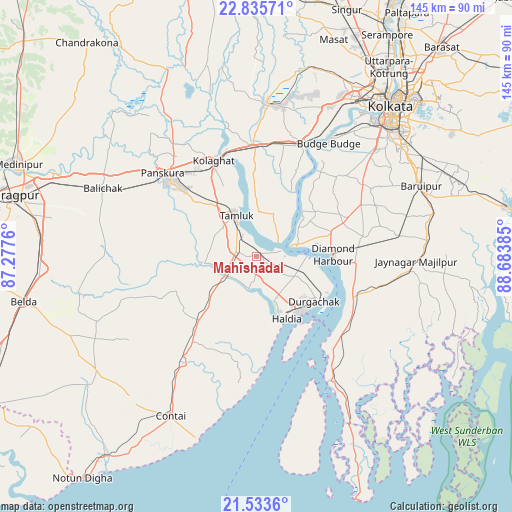
Mahīshādal GPS coordinates[2]
22° 11' 10.176" North, 87° 58' 50.592" East
| Map corner | latitude | longitude |
|---|---|---|
| Upper-left | 22.83571°, | 87.2776° |
| Center: | 22.18616°, | 87.98072° |
| Lower-right: | 21.5336°, | 88.68385° |
| Map W x H: | 144.8×144.8 km | = 90×90mi |
| max Lat: | 34.9274° ⇑55.4% North |
| Mahīshādal: | 22.18616° |
| min Lat: | ⇓44.6% South 8.09008° |
| min Long | Mahīshādal | max Long |
| 68.82655° | 87.98072° | 96.81° |
| W 91.1%⇐ | ⇒8.9% E |
Elevation
Elevation of Mahīshādal is 7 m = 23 ft, and this is 288.6 m = 947 ft below average elevation for this country.
| Max E: |
3681 m = 12077 ft | 99% |
| Avg. | 295.6 m = 970 ft | |
| Mahīshādal | 7 m = 23 ft | |
Min E: |
1 m = 3 ft | 1% |
See also: India elevation on elevation.city.
Geographical zone
Mahīshādal is located in North Torrid zone (between Equator and Tropic of Cancer). Distance of this Northern Tropic circle is 139 km =86.4 mi to North.| Distance of | km | miles | from Mahīshādal |
|---|---|---|---|
| North Pole | 7540.2 | 4685.3 | to North |
| Arctic Circle | 4934.3 | 3066 | to North |
| Tropic Cancer | 139 | 86.4 | to North |
| Equator | 2466.9 | 1532.9 | to South |


Nearby cities:
15 places around Mahīshādal: (largest is in red/bold)
• Amtala
36.9 km =22.9 mi,  56°
56°
• Baj Baj
38 km =23.6 mi,  32°
32°
• Balarāmpur
36.5 km =22.7 mi, 63°
• Bishnupur
36.9 km =22.9 mi,  54°
54°
• Bāwāli
34.5 km =21.4 mi,  39°
39°
• Diamond Harbour
21 km =13 mi,  87°
87°
• Fort Gloster
41.1 km =25.5 mi, 30°
• Haldia
19.3 km =12 mi,  136°
136°
• Harindānga
38.8 km =24.1 mi,  115°
115°
• Jāfarpur
29.6 km =18.4 mi, 60°
• Monoharpur
13.3 km =8.3 mi,  130°
130°
• Pujali
35.9 km =22.3 mi, 28°
• Serpur
37 km =23 mi,  65°
65°
• Solap
19.4 km =12.1 mi,  109°
109°
• Tamlūk
13.9 km =8.6 mi,  336°
336°
Sources, notices
• [Note1] Compared only with cities in India existing in our database
• [Src1] Map data: © OpenStreetMap contributors (CC-BY-SA)
• [Src2] Other city data from geonames.org with taken over terms of usage.
• [Src3] Geographical zone / Annual Mean Temperature by Robert A. Rohde @ Wikipedia
