Kattivākkam geodata
Kattivākkam (Tamil Nadu) is a populated place; located in India in Asia/Kolkata (GMT+5.5) time zone. With population of 34,595 people, there are 1256 cities with bigger population in this country. Compared to other cities in India, 85.2% of cities are located further ↑North; 70.4% of cities are located further ←West and 99.9% of cities have higher elevation than Kattivākkam. Note1


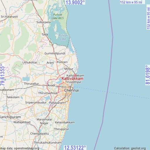
Kattivākkam GPS coordinates[2]
13° 13' 0.012" North, 80° 19' 0.012" East
| Map corner | latitude | longitude |
|---|---|---|
| Upper-left | 13.9002°, | 79.61355° |
| Center: | 13.21667°, | 80.31667° |
| Lower-right: | 12.53122°, | 81.0198° |
| Map W x H: | 152.2×152.2 km | = 94.6×94.6mi |
| max Lat: | 34.9274° ⇑85.2% North |
| Kattivākkam: | 13.21667° |
| min Lat: | ⇓14.8% South 8.09008° |
| min Long | Kattivākkam | max Long |
| 68.82655° | 80.31667° | 96.81° |
| W 70.4%⇐ | ⇒29.6% E |
Elevation
Elevation of Kattivākkam is 2 m = 7 ft, and this is 293.6 m = 963 ft below average elevation for this country.
| Max E: |
3681 m = 12077 ft | 99.9% |
| Avg. | 295.6 m = 970 ft | |
| Kattivākkam | 2 m = 7 ft | |
Min E: |
1 m = 3 ft | 0.1% |
See also: India elevation on elevation.city.
Geographical zone
Kattivākkam is located in North Torrid zone (between Equator and Tropic of Cancer). Distance of this Northern Tropic circle is 1136.4 km =706.1 mi to North.| Distance of | km | miles | from Kattivākkam |
|---|---|---|---|
| North Pole | 8537.5 | 5305 | to North |
| Arctic Circle | 5931.6 | 3685.7 | to North |
| Tropic Cancer | 1136.4 | 706.1 | to North |
| Equator | 1469.6 | 913.2 | to South |


Nearby cities:
15 places around Kattivākkam: (largest is in red/bold)
• Ambattūr
21.3 km =13.2 mi,  231°
231°
• Chennai
14.9 km =9.3 mi,  196°
196°
• Chetput
18.3 km =11.4 mi,  206°
206°
• Chinnasekkadu
8.9 km =5.5 mi, 226°
• George Town
14.4 km =8.9 mi, 196°
• Gāndhī Nagar
24.3 km =15.1 mi, 196°
• Manali
7.8 km =4.8 mi,  224°
224°
• Mīnjūr
9.4 km =5.8 mi,  317°
317°
• Nāravārikuppam
14.6 km =9.1 mi,  258°
258°
• Ponneri
18.9 km =11.7 mi, 315°
• Porur
26.4 km =16.4 mi, 220°
• Puduvāyal
22.4 km =13.9 mi,  304°
304°
• Tiruvottiyūr
6.7 km =4.2 mi,  193°
193°
• Vellānūr
23.7 km =14.7 mi,  254°
254°
• Āvadi
25.1 km =15.6 mi,  243°
243°
Sources, notices
• [Note1] Compared only with cities in India existing in our database
• [Src1] Map data: © OpenStreetMap contributors (CC-BY-SA)
• [Src2] Other city data from geonames.org with taken over terms of usage.
• [Src3] Geographical zone / Annual Mean Temperature by Robert A. Rohde @ Wikipedia
