Vellānūr geodata
Vellānūr (Tamil Nadu) is a populated place; located in India in Asia/Kolkata (GMT+5.5) time zone. With population of 6,078 people, there are 3285 cities with bigger population in this country. Compared to other cities in India, 85.6% of cities are located further ↑North; 68.6% of cities are located further ←West and 87.2% of cities have higher elevation than Vellānūr. Note1


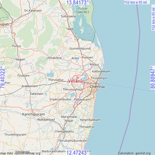
Vellānūr GPS coordinates[2]
13° 9' 28.944" North, 80° 6' 22.824" East
| Map corner | latitude | longitude |
|---|---|---|
| Upper-left | 13.84173°, | 79.40322° |
| Center: | 13.15804°, | 80.10634° |
| Lower-right: | 12.47243°, | 80.80947° |
| Map W x H: | 152.3×152.3 km | = 94.6×94.6mi |
| max Lat: | 34.9274° ⇑85.6% North |
| Vellānūr: | 13.15804° |
| min Lat: | ⇓14.4% South 8.09008° |
| min Long | Vellānūr | max Long |
| 68.82655° | 80.10634° | 96.81° |
| W 68.6%⇐ | ⇒31.4% E |
Elevation
Elevation of Vellānūr is 24 m = 79 ft, and this is 271.6 m = 891 ft below average elevation for this country.
| Max E: |
3681 m = 12077 ft | 87.2% |
| Avg. | 295.6 m = 970 ft | |
| Vellānūr | 24 m = 79 ft | |
Min E: |
1 m = 3 ft | 12.8% |
See also: India elevation on elevation.city.
Geographical zone
Vellānūr is located in North Torrid zone (between Equator and Tropic of Cancer). Distance of this Northern Tropic circle is 1142.9 km =710.2 mi to North.| Distance of | km | miles | from Vellānūr |
|---|---|---|---|
| North Pole | 8544 | 5309 | to North |
| Arctic Circle | 5938.1 | 3689.8 | to North |
| Tropic Cancer | 1142.9 | 710.2 | to North |
| Equator | 1463 | 909.1 | to South |


Nearby cities:
15 places around Vellānūr: (largest is in red/bold)
• Alandur
20.4 km =12.7 mi,  148°
148°
• Ambattūr
8.9 km =5.5 mi,  138°
138°
• Chennai
20.2 km =12.6 mi,  112°
112°
• Chetput
17.5 km =10.9 mi,  123°
123°
• Chinnasekkadu
16.3 km =10.1 mi,  88°
88°
• George Town
20.2 km =12.6 mi, 111°
• Manali
17.4 km =10.8 mi, 86°
• Manappakkam
17.7 km =11 mi,  157°
157°
• Nāravārikuppam
9.3 km =5.8 mi,  66°
66°
• Poonamalle
12.2 km =7.6 mi,  175°
175°
• Porur
14.7 km =9.1 mi, 157°
• Puduvāyal
19.6 km =12.2 mi,  12°
12°
• Saint Thomas Mount
19.8 km =12.3 mi, 150°
• Tinnanūr
9.8 km =6.1 mi,  240°
240°
• Āvadi
4.8 km =3 mi, 175°
Sources, notices
• [Note1] Compared only with cities in India existing in our database
• [Src1] Map data: © OpenStreetMap contributors (CC-BY-SA)
• [Src2] Other city data from geonames.org with taken over terms of usage.
• [Src3] Geographical zone / Annual Mean Temperature by Robert A. Rohde @ Wikipedia
