George Town geodata
George Town (Tamil Nadu) is a seat of a third-order administrative division; located in India in Asia/Kolkata (GMT+5.5) time zone. In our database, there are 3475 cities with bigger population. Compared to other cities in India, 85.9% of cities are located further ↑North; 70.2% of cities are located further ←West and 93.5% of cities have higher elevation than George Town. Note1


George Town GPS coordinates[2]
13° 5' 33.36" North, 80° 16' 48.36" East
| Map corner | latitude | longitude |
|---|---|---|
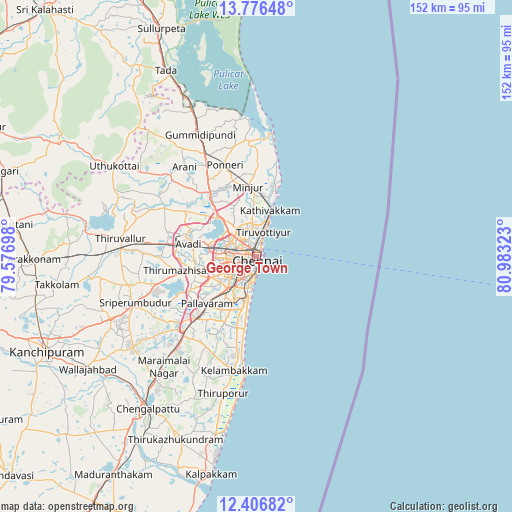
| Upper-left | 13.77648°, | 79.57698° |
| Center: | 13.0926°, | 80.2801° |
| Lower-right: | 12.40682°, | 80.98323° |
| Map W x H: | 152.3×152.3 km | = 94.6×94.6mi |
| max Lat: | 34.9274° ⇑85.9% North |
| George Town: | 13.0926° |
| min Lat: | ⇓14.1% South 8.09008° |
| min Long | George Town | max Long |
| 68.82655° | 80.2801° | 96.81° |
| W 70.2%⇐ | ⇒29.8% E |
Elevation
Elevation of George Town is 13 m = 43 ft, and this is 282.6 m = 927 ft below average elevation for this country.
| Max E: |
3681 m = 12077 ft | 93.5% |
| Avg. | 295.6 m = 970 ft | |
| George Town | 13 m = 43 ft | |
Min E: |
1 m = 3 ft | 6.5% |
See also: India elevation on elevation.city.
Geographical zone
George Town is located in North Torrid zone (between Equator and Tropic of Cancer). Distance of this Northern Tropic circle is 1150.2 km =714.7 mi to North.| Distance of | km | miles | from George Town |
|---|---|---|---|
| North Pole | 8551.3 | 5313.5 | to North |
| Arctic Circle | 5945.4 | 3694.3 | to North |
| Tropic Cancer | 1150.2 | 714.7 | to North |
| Equator | 1455.8 | 904.6 | to South |


Nearby cities:
15 places around George Town: (largest is in red/bold)
• Alandur
12.8 km =8 mi,  218°
218°
• Ambattūr
12.9 km =8 mi,  272°
272°
• Chennai
0.6 km =0.4 mi,  198°
198°
• Chetput
4.9 km =3 mi,  239°
239°
• Chinnasekkadu
8 km =5 mi,  341°
341°
• Gāndhī Nagar
10 km =6.2 mi, 196°
• Kattivākkam
14.4 km =8.9 mi,  16°
16°
• Manali
8.4 km =5.2 mi,  349°
349°
• Manappakkam
15.1 km =9.4 mi,  233°
233°
• Nāravārikuppam
15.1 km =9.4 mi,  316°
316°
• Palavakkam
15.7 km =9.8 mi,  189°
189°
• Perungudi
15.2 km =9.4 mi, 196°
• Porur
14.6 km =9.1 mi, 244°
• Saint Thomas Mount
13.5 km =8.4 mi, 222°
• Tiruvottiyūr
7.7 km =4.8 mi, 17°
Sources, notices
• [Note1] Compared only with cities in India existing in our database
• [Src1] Map data: © OpenStreetMap contributors (CC-BY-SA)
• [Src2] Other city data from geonames.org with taken over terms of usage.
• [Src3] Geographical zone / Annual Mean Temperature by Robert A. Rohde @ Wikipedia
