Kalyani geodata
Kalyani (West Bengal) is a populated place; located in India in Asia/Kolkata (GMT+5.5) time zone. With population of 93,184 people, there are 479 cities with bigger population in this country. Compared to other cities in India, 51.5% of cities are located further ↓South; 94.2% of cities are located further ←West and 92.8% of cities have higher elevation than Kalyani. Note1


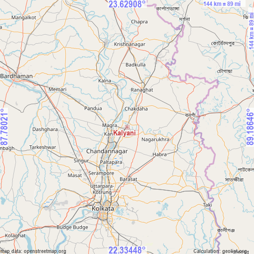
Kalyani GPS coordinates[2]
22° 58' 59.988" North, 88° 28' 59.988" East
| Map corner | latitude | longitude |
|---|---|---|
| Upper-left | 23.62908°, | 87.78021° |
| Center: | 22.98333°, | 88.48333° |
| Lower-right: | 22.33448°, | 89.18646° |
| Map W x H: | 143.9×143.9 km | = 89.4×89.4mi |
| max Lat: | 34.9274° ⇑48.5% North |
| Kalyani: | 22.98333° |
| min Lat: | ⇓51.5% South 8.09008° |
| min Long | Kalyani | max Long |
| 68.82655° | 88.48333° | 96.81° |
| W 94.2%⇐ | ⇒5.8% E |
Elevation
Elevation of Kalyani is 14 m = 46 ft, and this is 281.6 m = 924 ft below average elevation for this country.
| Max E: |
3681 m = 12077 ft | 92.8% |
| Avg. | 295.6 m = 970 ft | |
| Kalyani | 14 m = 46 ft | |
Min E: |
1 m = 3 ft | 7.2% |
See also: Kalyani elevation on elevation.city.
Geographical zone
Kalyani is located in North Torrid zone (between Equator and Tropic of Cancer). Distance of this Northern Tropic circle is 50.4 km =31.3 mi to North.| Distance of | km | miles | from Kalyani |
|---|---|---|---|
| North Pole | 7451.6 | 4630.2 | to North |
| Arctic Circle | 4845.7 | 3011 | to North |
| Tropic Cancer | 50.4 | 31.3 | to North |
| Equator | 2555.5 | 1587.9 | to South |


Nearby cities:
15 places around Kalyani: (largest is in red/bold)
• Ashoknagar Kalyangarh
20.6 km =12.8 mi,  130°
130°
• Bhātpāra
15.5 km =9.6 mi,  212°
212°
• Bānsbāria
9 km =5.6 mi,  248°
248°
• Chandannagar
17.9 km =11.1 mi,  221°
221°
• Haringhāta
9.6 km =6 mi,  102°
102°
• Hugli
12.1 km =7.5 mi,  226°
226°
• Hālīsahar
8.7 km =5.4 mi, 229°
• Kesabpur
22.6 km =14 mi,  265°
265°
• Kānchrāpāra
6.2 km =3.9 mi, 245°
• Madanpur
2.7 km =1.7 mi,  18°
18°
• Nagarukhra
16.4 km =10.2 mi,  106°
106°
• Naihāti
12.1 km =7.5 mi, 215°
• Rāmchandrapur
9.7 km =6 mi,  184°
184°
• Sankarpur
15.4 km =9.6 mi,  192°
192°
• Shyamnagar
20.5 km =12.7 mi, 215°
Sources, notices
• [Note1] Compared only with cities in India existing in our database
• [Src1] Map data: © OpenStreetMap contributors (CC-BY-SA)
• [Src2] Other city data from geonames.org with taken over terms of usage.
• [Src3] Geographical zone / Annual Mean Temperature by Robert A. Rohde @ Wikipedia
