Hālīsahar geodata
Hālīsahar (West Bengal) is a populated place; located in India in Asia/Kolkata (GMT+5.5) time zone. With population of 128,172 people, there are 342 cities with bigger population in this country. Compared to other cities in India, 51% of cities are located further ↓South; 93.8% of cities are located further ←West and 91.1% of cities have higher elevation than Hālīsahar. Note1


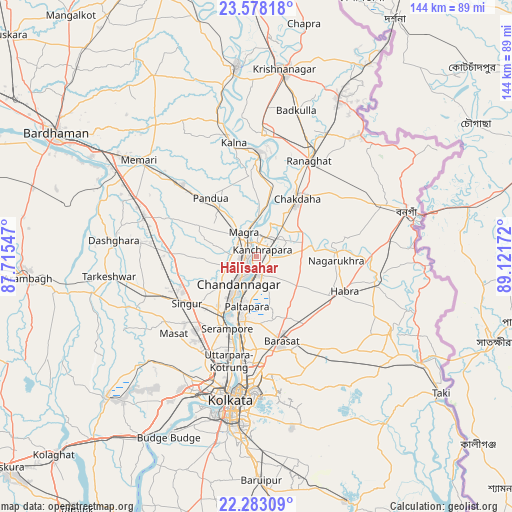
Hālīsahar GPS coordinates[2]
22° 55' 55.848" North, 88° 25' 6.924" East
| Map corner | latitude | longitude |
|---|---|---|
| Upper-left | 23.57818°, | 87.71547° |
| Center: | 22.93218°, | 88.41859° |
| Lower-right: | 22.28309°, | 89.12172° |
| Map W x H: | 144×144 km | = 89.5×89.5mi |
| max Lat: | 34.9274° ⇑49% North |
| Hālīsahar: | 22.93218° |
| min Lat: | ⇓51% South 8.09008° |
| min Long | Hālīsahar | max Long |
| 68.82655° | 88.41859° | 96.81° |
| W 93.8%⇐ | ⇒6.2% E |
Elevation
Elevation of Hālīsahar is 16 m = 52 ft, and this is 279.6 m = 917 ft below average elevation for this country.
| Max E: |
3681 m = 12077 ft | 91.1% |
| Avg. | 295.6 m = 970 ft | |
| Hālīsahar | 16 m = 52 ft | |
Min E: |
1 m = 3 ft | 8.9% |
See also: Hālīsahar elevation on elevation.city.
Geographical zone
Hālīsahar is located in North Torrid zone (between Equator and Tropic of Cancer). Distance of this Northern Tropic circle is 56.1 km =34.9 mi to North.| Distance of | km | miles | from Hālīsahar |
|---|---|---|---|
| North Pole | 7457.2 | 4633.7 | to North |
| Arctic Circle | 4851.4 | 3014.5 | to North |
| Tropic Cancer | 56.1 | 34.9 | to North |
| Equator | 2549.8 | 1584.4 | to South |


Nearby cities:
15 places around Hālīsahar: (largest is in red/bold)
• Baidyabāti
18.9 km =11.7 mi,  210°
210°
• Bhadreswar
14.5 km =9 mi, 214°
• Bhātpāra
7.5 km =4.7 mi,  193°
193°
• Bānsbāria
3 km =1.9 mi,  323°
323°
• Chandannagar
9.3 km =5.8 mi, 213°
• Haringhāta
16.4 km =10.2 mi,  77°
77°
• Hugli
3.4 km =2.1 mi,  220°
220°
• Kalyani
8.7 km =5.4 mi,  49°
49°
• Kesabpur
16.5 km =10.3 mi,  284°
284°
• Kānchrāpāra
3.3 km =2.1 mi,  18°
18°
• Madanpur
11.1 km =6.9 mi,  42°
42°
• Naihāti
4.3 km =2.7 mi,  184°
184°
• Rāmchandrapur
7 km =4.3 mi,  124°
124°
• Sankarpur
9.9 km =6.2 mi,  160°
160°
• Shyamnagar
12.2 km =7.6 mi, 205°
Sources, notices
• [Note1] Compared only with cities in India existing in our database
• [Src1] Map data: © OpenStreetMap contributors (CC-BY-SA)
• [Src2] Other city data from geonames.org with taken over terms of usage.
• [Src3] Geographical zone / Annual Mean Temperature by Robert A. Rohde @ Wikipedia
