Kānchrāpāra geodata
Kānchrāpāra (West Bengal) is a populated place; located in India in Asia/Kolkata (GMT+5.5) time zone. With population of 136,954 people, there are 317 cities with bigger population in this country. Compared to other cities in India, 51.3% of cities are located further ↓South; 93.8% of cities are located further ←West and 96.4% of cities have higher elevation than Kānchrāpāra. Note1


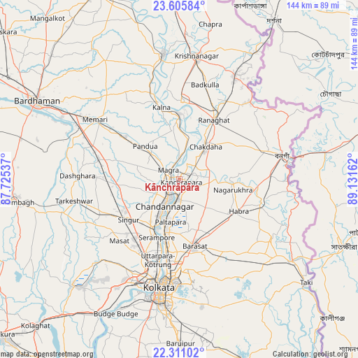
Kānchrāpāra GPS coordinates[2]
22° 57' 35.928" North, 88° 25' 42.564" East
| Map corner | latitude | longitude |
|---|---|---|
| Upper-left | 23.60584°, | 87.72537° |
| Center: | 22.95998°, | 88.42849° |
| Lower-right: | 22.31102°, | 89.13162° |
| Map W x H: | 144×144 km | = 89.5×89.5mi |
| max Lat: | 34.9274° ⇑48.7% North |
| Kānchrāpāra: | 22.95998° |
| min Lat: | ⇓51.3% South 8.09008° |
| min Long | Kānchrāpāra | max Long |
| 68.82655° | 88.42849° | 96.81° |
| W 93.8%⇐ | ⇒6.2% E |
Elevation
Elevation of Kānchrāpāra is 10 m = 33 ft, and this is 285.6 m = 937 ft below average elevation for this country.
| Max E: |
3681 m = 12077 ft | 96.4% |
| Avg. | 295.6 m = 970 ft | |
| Kānchrāpāra | 10 m = 33 ft | |
Min E: |
1 m = 3 ft | 3.6% |
See also: Kānchrāpāra elevation on elevation.city.
Geographical zone
Kānchrāpāra is located in North Torrid zone (between Equator and Tropic of Cancer). Distance of this Northern Tropic circle is 53 km =32.9 mi to North.| Distance of | km | miles | from Kānchrāpāra |
|---|---|---|---|
| North Pole | 7454.2 | 4631.8 | to North |
| Arctic Circle | 4848.3 | 3012.6 | to North |
| Tropic Cancer | 53 | 32.9 | to North |
| Equator | 2552.9 | 1586.3 | to South |


Nearby cities:
15 places around Kānchrāpāra: (largest is in red/bold)
• Bhadreswar
17.7 km =11 mi,  211°
211°
• Bhātpāra
10.8 km =6.7 mi,  195°
195°
• Bānsbāria
2.9 km =1.8 mi,  256°
256°
• Chandannagar
12.5 km =7.8 mi, 209°
• Haringhāta
15 km =9.3 mi,  87°
87°
• Hugli
6.6 km =4.1 mi, 209°
• Hālīsahar
3.3 km =2.1 mi, 198°
• Kalyani
6.2 km =3.9 mi,  65°
65°
• Kesabpur
17 km =10.6 mi,  273°
273°
• Madanpur
8.2 km =5.1 mi,  51°
51°
• Naihāti
7.5 km =4.7 mi,  190°
190°
• Pandua
19.4 km =12.1 mi,  311°
311°
• Rāmchandrapur
8.5 km =5.3 mi,  145°
145°
• Sankarpur
12.6 km =7.8 mi,  169°
169°
• Shyamnagar
15.4 km =9.6 mi, 204°
Sources, notices
• [Note1] Compared only with cities in India existing in our database
• [Src1] Map data: © OpenStreetMap contributors (CC-BY-SA)
• [Src2] Other city data from geonames.org with taken over terms of usage.
• [Src3] Geographical zone / Annual Mean Temperature by Robert A. Rohde @ Wikipedia
