Dholka geodata
Dholka (Gujarat) is a populated place; located in India in Asia/Kolkata (GMT+5.5) time zone. With population of 54,977 people, there are 810 cities with bigger population in this country. Compared to other cities in India, 50.6% of cities are located further ↑North; 96.8% of cities are located further →East and 86.4% of cities have higher elevation than Dholka. Note1


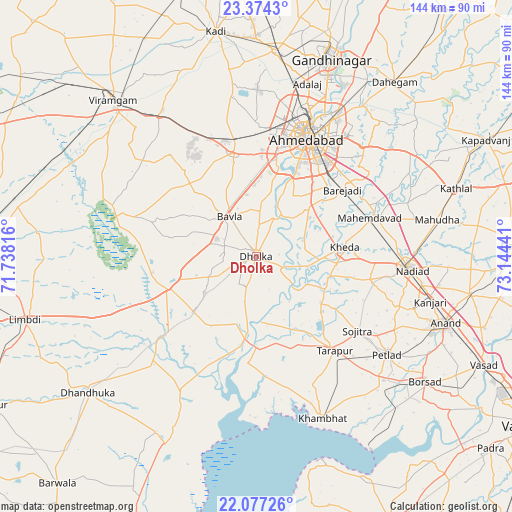
Dholka GPS coordinates[2]
22° 43' 38.352" North, 72° 26' 28.608" East
| Map corner | latitude | longitude |
|---|---|---|
| Upper-left | 23.3743°, | 71.73816° |
| Center: | 22.72732°, | 72.44128° |
| Lower-right: | 22.07726°, | 73.14441° |
| Map W x H: | 144.2×144.2 km | = 89.6×89.6mi |
| max Lat: | 34.9274° ⇑50.6% North |
| Dholka: | 22.72732° |
| min Lat: | ⇓49.4% South 8.09008° |
| min Long | Dholka | max Long |
| 68.82655° | 72.44128° | 96.81° |
| W 3.2%⇐ | ⇒96.8% E |
Elevation
Elevation of Dholka is 26 m = 85 ft, and this is 269.6 m = 885 ft below average elevation for this country.
| Max E: |
3681 m = 12077 ft | 86.4% |
| Avg. | 295.6 m = 970 ft | |
| Dholka | 26 m = 85 ft | |
Min E: |
1 m = 3 ft | 13.6% |
See also: Dholka elevation on elevation.city.
Geographical zone
Dholka is located in North Torrid zone (between Equator and Tropic of Cancer). Distance of this Northern Tropic circle is 78.9 km =49 mi to North.| Distance of | km | miles | from Dholka |
|---|---|---|---|
| North Pole | 7480 | 4647.9 | to North |
| Arctic Circle | 4874.1 | 3028.6 | to North |
| Tropic Cancer | 78.9 | 49 | to North |
| Equator | 2527 | 1570.2 | to South |


Nearby cities:
15 places around Dholka: (largest is in red/bold)
• Adalaj
50.7 km =31.5 mi,  16°
16°
• Ahmedabad
36.4 km =22.6 mi, 24°
• Karamsad
51.7 km =32.1 mi,  113°
113°
• Khambhāt
49.1 km =30.5 mi,  158°
158°
• Kheda
25.2 km =15.7 mi,  83°
83°
• Mahemdāvād
33.9 km =21.1 mi,  71°
71°
• Mahudha
52.2 km =32.4 mi, 78°
• Nadiād
43.3 km =26.9 mi,  94°
94°
• Naroda
44.1 km =27.4 mi,  30°
30°
• Petlād
46.2 km =28.7 mi,  127°
127°
• Sarkhej
29.1 km =18.1 mi,  12°
12°
• Sojītra
35.4 km =22 mi, 126°
• Sānand
30.1 km =18.7 mi,  348°
348°
• Vallabh Vidyanagar
51.8 km =32.2 mi, 114°
• Vasa
33 km =20.5 mi,  102°
102°
Sources, notices
• [Note1] Compared only with cities in India existing in our database
• [Src1] Map data: © OpenStreetMap contributors (CC-BY-SA)
• [Src2] Other city data from geonames.org with taken over terms of usage.
• [Src3] Geographical zone / Annual Mean Temperature by Robert A. Rohde @ Wikipedia
