Adalaj geodata
Adalaj (Gujarat) is a populated place; located in India in Asia/Kolkata (GMT+5.5) time zone. With population of 10,423 people, there are 2898 cities with bigger population in this country. Compared to other cities in India, 52.6% of cities are located further ↓South; 96.7% of cities are located further →East and 74.6% of cities have higher elevation than Adalaj. Note1


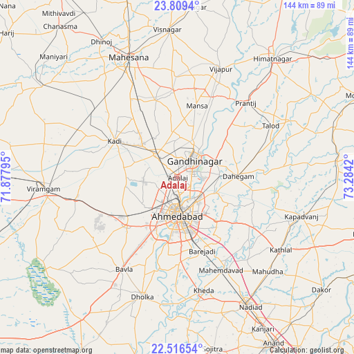
Adalaj GPS coordinates[2]
23° 9' 52.308" North, 72° 34' 51.852" East
| Map corner | latitude | longitude |
|---|---|---|
| Upper-left | 23.8094°, | 71.87795° |
| Center: | 23.16453°, | 72.58107° |
| Lower-right: | 22.51654°, | 73.2842° |
| Map W x H: | 143.8×143.8 km | = 89.4×89.4mi |
| max Lat: | 34.9274° ⇑47.4% North |
| Adalaj: | 23.16453° |
| min Lat: | ⇓52.6% South 8.09008° |
| min Long | Adalaj | max Long |
| 68.82655° | 72.58107° | 96.81° |
| W 3.3%⇐ | ⇒96.7% E |
Elevation
Elevation of Adalaj is 70 m = 230 ft, and this is 225.6 m = 740 ft below average elevation for this country.
| Max E: |
3681 m = 12077 ft | 74.6% |
| Avg. | 295.6 m = 970 ft | |
| Adalaj | 70 m = 230 ft | |
Min E: |
1 m = 3 ft | 25.4% |
See also: India elevation on elevation.city.
Geographical zone
Adalaj is located in North Torrid zone (between Equator and Tropic of Cancer). Distance of this Northern Tropic circle is 30.3 km =18.8 mi to North.| Distance of | km | miles | from Adalaj |
|---|---|---|---|
| North Pole | 7431.4 | 4617.7 | to North |
| Arctic Circle | 4825.5 | 2998.4 | to North |
| Tropic Cancer | 30.3 | 18.8 | to North |
| Equator | 2575.7 | 1600.5 | to South |


Nearby cities:
15 places around Adalaj: (largest is in red/bold)
• Ahmedabad
15.4 km =9.6 mi,  177°
177°
• Chhala
25.3 km =15.7 mi,  51°
51°
• Dahegām
24.6 km =15.3 mi,  88°
88°
• Dholka
50.7 km =31.5 mi,  196°
196°
• Gandhinagar
12 km =7.5 mi,  60°
60°
• Jhulasan
21.3 km =13.2 mi,  328°
328°
• Kadi
29.4 km =18.3 mi,  300°
300°
• Kapadvanj
52.5 km =32.6 mi,  107°
107°
• Kheda
47.1 km =29.3 mi,  166°
166°
• Mahemdāvād
41.9 km =26 mi,  154°
154°
• Mānsa
30.1 km =18.7 mi,  15°
15°
• Naroda
13 km =8.1 mi,  143°
143°
• Sarkhej
21.7 km =13.5 mi, 201°
• Sānand
28 km =17.4 mi,  226°
226°
• Vijāpur
47.4 km =29.5 mi, 21°
Sources, notices
• [Note1] Compared only with cities in India existing in our database
• [Src1] Map data: © OpenStreetMap contributors (CC-BY-SA)
• [Src2] Other city data from geonames.org with taken over terms of usage.
• [Src3] Geographical zone / Annual Mean Temperature by Robert A. Rohde @ Wikipedia
