Arambol geodata
Arambol (Goa) is a populated place; located in India in Asia/Kolkata (GMT+5.5) time zone. With population of 10,000 people, there are 2941 cities with bigger population in this country. Compared to other cities in India, 78.9% of cities are located further ↑North; 91.8% of cities are located further →East and 99% of cities have higher elevation than Arambol. Note1


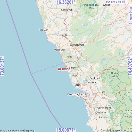
Arambol GPS coordinates[2]
15° 41' 12.516" North, 73° 42' 16.164" East
| Map corner | latitude | longitude |
|---|---|---|
| Upper-left | 16.36261°, | 73.00137° |
| Center: | 15.68681°, | 73.70449° |
| Lower-right: | 15.00877°, | 74.40762° |
| Map W x H: | 150.5×150.5 km | = 93.5×93.5mi |
| max Lat: | 34.9274° ⇑78.9% North |
| Arambol: | 15.68681° |
| min Lat: | ⇓21.1% South 8.09008° |
| min Long | Arambol | max Long |
| 68.82655° | 73.70449° | 96.81° |
| W 8.2%⇐ | ⇒91.8% E |
Elevation
Elevation of Arambol is 7 m = 23 ft, and this is 288.6 m = 947 ft below average elevation for this country.
| Max E: |
3681 m = 12077 ft | 99% |
| Avg. | 295.6 m = 970 ft | |
| Arambol | 7 m = 23 ft | |
Min E: |
1 m = 3 ft | 1% |
See also: India elevation on elevation.city.
Geographical zone
Arambol is located in North Torrid zone (between Equator and Tropic of Cancer). Distance of this Northern Tropic circle is 861.7 km =535.4 mi to North.| Distance of | km | miles | from Arambol |
|---|---|---|---|
| North Pole | 8262.9 | 5134.3 | to North |
| Arctic Circle | 5657 | 3515.1 | to North |
| Tropic Cancer | 861.7 | 535.4 | to North |
| Equator | 1744.2 | 1083.8 | to South |


Nearby cities:
15 places around Arambol: (largest is in red/bold)
• Aldona
21 km =13 mi,  119°
119°
• Baga
14.6 km =9.1 mi,  158°
158°
• Calangute
16.8 km =10.4 mi, 161°
• Candolim
19.8 km =12.3 mi, 161°
• Chapora
10 km =6.2 mi, 157°
• Colovale
14 km =8.7 mi,  114°
114°
• Guirim
16.6 km =10.3 mi,  138°
138°
• Morjim
7.2 km =4.5 mi,  149°
149°
• Māpuca
15.4 km =9.6 mi,  133°
133°
• Pernem
10.5 km =6.5 mi,  67°
67°
• Saligao
17.4 km =10.8 mi, 148°
• Serula
21.4 km =13.3 mi, 136°
• Solim
10.4 km =6.5 mi, 139°
• Vagator
10.8 km =6.7 mi, 156°
• Vengurla
20.9 km =13 mi,  338°
338°
Sources, notices
• [Note1] Compared only with cities in India existing in our database
• [Src1] Map data: © OpenStreetMap contributors (CC-BY-SA)
• [Src2] Other city data from geonames.org with taken over terms of usage.
• [Src3] Geographical zone / Annual Mean Temperature by Robert A. Rohde @ Wikipedia
