Āmta geodata
Āmta (West Bengal) is a populated place; located in India in Asia/Kolkata (GMT+5.5) time zone. With population of 16,753 people, there are 2305 cities with bigger population in this country. Compared to other cities in India, 52.4% of cities are located further ↑North; 91.1% of cities are located further ←West and 94.3% of cities have higher elevation than Āmta. Note1


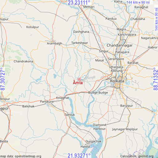
Āmta GPS coordinates[2]
22° 35' 0.384" North, 88° 0' 37.404" East
| Map corner | latitude | longitude |
|---|---|---|
| Upper-left | 23.23111°, | 87.30727° |
| Center: | 22.58344°, | 88.01039° |
| Lower-right: | 21.93271°, | 88.71352° |
| Map W x H: | 144.4×144.4 km | = 89.7×89.7mi |
| max Lat: | 34.9274° ⇑52.4% North |
| Āmta: | 22.58344° |
| min Lat: | ⇓47.6% South 8.09008° |
| min Long | Āmta | max Long |
| 68.82655° | 88.01039° | 96.81° |
| W 91.1%⇐ | ⇒8.9% E |
Elevation
Elevation of Āmta is 12 m = 39 ft, and this is 283.6 m = 930 ft below average elevation for this country.
| Max E: |
3681 m = 12077 ft | 94.3% |
| Avg. | 295.6 m = 970 ft | |
| Āmta | 12 m = 39 ft | |
Min E: |
1 m = 3 ft | 5.7% |
See also: India elevation on elevation.city.
Geographical zone
Āmta is located in North Torrid zone (between Equator and Tropic of Cancer). Distance of this Northern Tropic circle is 94.9 km =59 mi to North.| Distance of | km | miles | from Āmta |
|---|---|---|---|
| North Pole | 7496 | 4657.8 | to North |
| Arctic Circle | 4890.1 | 3038.6 | to North |
| Tropic Cancer | 94.9 | 59 | to North |
| Equator | 2511 | 1560.3 | to South |


Nearby cities:
15 places around Āmta: (largest is in red/bold)
• Baj Baj
21 km =13 mi,  125°
125°
• Bhandārdaha
19 km =11.8 mi,  79°
79°
• Dhulagari
16.5 km =10.3 mi,  90°
90°
• Dumjor
24.5 km =15.2 mi, 80°
• Fort Gloster
19.8 km =12.3 mi,  116°
116°
• Gobindapur
8.4 km =5.2 mi, 82°
• Mahiari
23.1 km =14.4 mi, 88°
• Masila
22.8 km =14.2 mi, 90°
• Nangi
22.6 km =14 mi,  111°
111°
• Parbatipur
23.5 km =14.6 mi,  67°
67°
• Pujali
18.7 km =11.6 mi, 132°
• Pānchla
14.1 km =8.8 mi, 111°
• Raghudebbati
20.1 km =12.5 mi, 108°
• Sāhāpur
17.4 km =10.8 mi, 112°
• Sānkrāil
22.4 km =13.9 mi,  99°
99°
Sources, notices
• [Note1] Compared only with cities in India existing in our database
• [Src1] Map data: © OpenStreetMap contributors (CC-BY-SA)
• [Src2] Other city data from geonames.org with taken over terms of usage.
• [Src3] Geographical zone / Annual Mean Temperature by Robert A. Rohde @ Wikipedia
