Carapur geodata
Carapur (Goa) is a populated place; located in India in Asia/Kolkata (GMT+5.5) time zone. With population of 5,575 people, there are 3318 cities with bigger population in this country. Compared to other cities in India, 79.4% of cities are located further ↑North; 89.5% of cities are located further →East and 83% of cities have higher elevation than Carapur. Note1


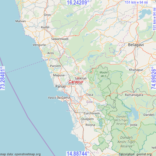
Carapur GPS coordinates[2]
15° 33' 57.168" North, 73° 59' 13.668" East
| Map corner | latitude | longitude |
|---|---|---|
| Upper-left | 16.24209°, | 73.28401° |
| Center: | 15.56588°, | 73.98713° |
| Lower-right: | 14.88744°, | 74.69026° |
| Map W x H: | 150.6×150.6 km | = 93.6×93.6mi |
| max Lat: | 34.9274° ⇑79.4% North |
| Carapur: | 15.56588° |
| min Lat: | ⇓20.6% South 8.09008° |
| min Long | Carapur | max Long |
| 68.82655° | 73.98713° | 96.81° |
| W 10.5%⇐ | ⇒89.5% E |
Elevation
Elevation of Carapur is 37 m = 121 ft, and this is 258.6 m = 848 ft below average elevation for this country.
| Max E: |
3681 m = 12077 ft | 83% |
| Avg. | 295.6 m = 970 ft | |
| Carapur | 37 m = 121 ft | |
Min E: |
1 m = 3 ft | 17% |
See also: India elevation on elevation.city.
Geographical zone
Carapur is located in North Torrid zone (between Equator and Tropic of Cancer). Distance of this Northern Tropic circle is 875.2 km =543.8 mi to North.| Distance of | km | miles | from Carapur |
|---|---|---|---|
| North Pole | 8276.3 | 5142.7 | to North |
| Arctic Circle | 5670.4 | 3523.4 | to North |
| Tropic Cancer | 875.2 | 543.8 | to North |
| Equator | 1730.8 | 1075.5 | to South |


Nearby cities:
15 places around Carapur: (largest is in red/bold)
• Aldona
12.4 km =7.7 mi,  284°
284°
• Bambolim
18.3 km =11.4 mi,  231°
231°
• Bandora
17.5 km =10.9 mi,  182°
182°
• Colovale
19.1 km =11.9 mi,  293°
293°
• Curti
16.9 km =10.5 mi,  169°
169°
• Dicholi
5.4 km =3.4 mi,  304°
304°
• Goa Velha
17.4 km =10.8 mi,  218°
218°
• Jua
5.5 km =3.4 mi, 225°
• Navelim
3.6 km =2.2 mi,  186°
186°
• Palle
15.1 km =9.4 mi,  136°
136°
• Panaji
18.9 km =11.7 mi,  245°
245°
• Ponda
18.3 km =11.4 mi, 170°
• Sanquelim
2.2 km =1.4 mi,  94°
94°
• Serula
15.5 km =9.6 mi,  262°
262°
• Valpoy
16.5 km =10.3 mi,  103°
103°
Sources, notices
• [Note1] Compared only with cities in India existing in our database
• [Src1] Map data: © OpenStreetMap contributors (CC-BY-SA)
• [Src2] Other city data from geonames.org with taken over terms of usage.
• [Src3] Geographical zone / Annual Mean Temperature by Robert A. Rohde @ Wikipedia
