Bāgnān geodata
Bāgnān (West Bengal) is a populated place; located in India in Asia/Kolkata (GMT+5.5) time zone. With population of 8,494 people, there are 3083 cities with bigger population in this country. Compared to other cities in India, 51.1% of cities are located further ↓South; 91.5% of cities are located further ←West and 91.9% of cities have higher elevation than Bāgnān. Note1


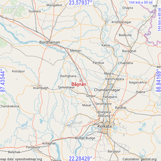
Bāgnān GPS coordinates[2]
22° 56' 0.168" North, 88° 8' 18.816" East
| Map corner | latitude | longitude |
|---|---|---|
| Upper-left | 23.57937°, | 87.43544° |
| Center: | 22.93338°, | 88.13856° |
| Lower-right: | 22.28429°, | 88.84169° |
| Map W x H: | 144×144 km | = 89.5×89.5mi |
| max Lat: | 34.9274° ⇑48.9% North |
| Bāgnān: | 22.93338° |
| min Lat: | ⇓51.1% South 8.09008° |
| min Long | Bāgnān | max Long |
| 68.82655° | 88.13856° | 96.81° |
| W 91.5%⇐ | ⇒8.5% E |
Elevation
Elevation of Bāgnān is 15 m = 49 ft, and this is 280.6 m = 921 ft below average elevation for this country.
| Max E: |
3681 m = 12077 ft | 91.9% |
| Avg. | 295.6 m = 970 ft | |
| Bāgnān | 15 m = 49 ft | |
Min E: |
1 m = 3 ft | 8.1% |
See also: India elevation on elevation.city.
Geographical zone
Bāgnān is located in North Torrid zone (between Equator and Tropic of Cancer). Distance of this Northern Tropic circle is 56 km =34.8 mi to North.| Distance of | km | miles | from Bāgnān |
|---|---|---|---|
| North Pole | 7457.1 | 4633.6 | to North |
| Arctic Circle | 4851.2 | 3014.4 | to North |
| Tropic Cancer | 56 | 34.8 | to North |
| Equator | 2550 | 1584.5 | to South |


Nearby cities:
15 places around Bāgnān: (largest is in red/bold)
• Baidyabāti
25.3 km =15.7 mi,  130°
130°
• Begampur
25.6 km =15.9 mi,  151°
151°
• Bhadreswar
23.8 km =14.8 mi,  120°
120°
• Bānsbāria
27 km =16.8 mi,  85°
85°
• Chandannagar
24.8 km =15.4 mi,  108°
108°
• Gangadharpur
21 km =13 mi,  156°
156°
• Haripur
9.6 km =6 mi, 88°
• Hugli
26.6 km =16.5 mi,  95°
95°
• Kesabpur
13.3 km =8.3 mi,  73°
73°
• Pandua
21.8 km =13.5 mi,  43°
43°
• Rāmnagar
20.5 km =12.7 mi, 147°
• Shyamnagar
25.9 km =16.1 mi, 115°
• Singur
16.7 km =10.4 mi, 146°
• Srirāmpur
12.3 km =7.6 mi,  277°
277°
• Tarakeswar
13.8 km =8.6 mi,  247°
247°
Sources, notices
• [Note1] Compared only with cities in India existing in our database
• [Src1] Map data: © OpenStreetMap contributors (CC-BY-SA)
• [Src2] Other city data from geonames.org with taken over terms of usage.
• [Src3] Geographical zone / Annual Mean Temperature by Robert A. Rohde @ Wikipedia
