Rāmnagar geodata
Rāmnagar (West Bengal) is a populated place; located in India in Asia/Kolkata (GMT+5.5) time zone. With population of 5,195 people, there are 3333 cities with bigger population in this country. Compared to other cities in India, 50.1% of cities are located further ↑North; 92.3% of cities are located further ←West and 96.4% of cities have higher elevation than Rāmnagar. Note1


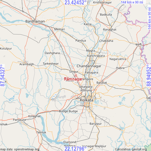
Rāmnagar GPS coordinates[2]
22° 46' 40.008" North, 88° 14' 47.004" East
| Map corner | latitude | longitude |
|---|---|---|
| Upper-left | 23.42452°, | 87.54327° |
| Center: | 22.77778°, | 88.24639° |
| Lower-right: | 22.12796°, | 88.94952° |
| Map W x H: | 144.2×144.2 km | = 89.6×89.6mi |
| max Lat: | 34.9274° ⇑50.1% North |
| Rāmnagar: | 22.77778° |
| min Lat: | ⇓49.9% South 8.09008° |
| min Long | Rāmnagar | max Long |
| 68.82655° | 88.24639° | 96.81° |
| W 92.3%⇐ | ⇒7.7% E |
Elevation
Elevation of Rāmnagar is 10 m = 33 ft, and this is 285.6 m = 937 ft below average elevation for this country.
| Max E: |
3681 m = 12077 ft | 96.4% |
| Avg. | 295.6 m = 970 ft | |
| Rāmnagar | 10 m = 33 ft | |
Min E: |
1 m = 3 ft | 3.6% |
See also: India elevation on elevation.city.
Geographical zone
Rāmnagar is located in North Torrid zone (between Equator and Tropic of Cancer). Distance of this Northern Tropic circle is 73.3 km =45.5 mi to North.| Distance of | km | miles | from Rāmnagar |
|---|---|---|---|
| North Pole | 7474.4 | 4644.4 | to North |
| Arctic Circle | 4868.5 | 3025.1 | to North |
| Tropic Cancer | 73.3 | 45.5 | to North |
| Equator | 2532.7 | 1573.7 | to South |


Nearby cities:
15 places around Rāmnagar: (largest is in red/bold)
• Baidyabāti
8.2 km =5.1 mi,  84°
84°
• Begampur
5.4 km =3.4 mi,  167°
167°
• Bhadreswar
10.8 km =6.7 mi,  61°
61°
• Bārākpur
12.1 km =7.5 mi,  96°
96°
• Chandannagar
15.6 km =9.7 mi,  52°
52°
• Gangadharpur
3.4 km =2.1 mi,  233°
233°
• Khardah
15 km =9.3 mi,  115°
115°
• Konnagar
12.9 km =8 mi,  128°
128°
• Krishnapur
12.2 km =7.6 mi, 168°
• Parbatipur
13.1 km =8.1 mi,  190°
190°
• Rishra
11.8 km =7.3 mi, 120°
• Shrīrāmpur
10.2 km =6.3 mi,  105°
105°
• Shyamnagar
13.8 km =8.6 mi, 63°
• Singur
3.9 km =2.4 mi,  333°
333°
• Titāgarh
13.6 km =8.5 mi, 106°
Sources, notices
• [Note1] Compared only with cities in India existing in our database
• [Src1] Map data: © OpenStreetMap contributors (CC-BY-SA)
• [Src2] Other city data from geonames.org with taken over terms of usage.
• [Src3] Geographical zone / Annual Mean Temperature by Robert A. Rohde @ Wikipedia
