Bhadreswar geodata
Bhadreswar (West Bengal) is a populated place; located in India in Asia/Kolkata (GMT+5.5) time zone. With population of 121,662 people, there are 362 cities with bigger population in this country. Compared to other cities in India, 50.2% of cities are located further ↓South; 93% of cities are located further ←West and 95.4% of cities have higher elevation than Bhadreswar. Note1


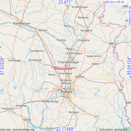
Bhadreswar GPS coordinates[2]
22° 49' 28.164" North, 88° 20' 18.276" East
| Map corner | latitude | longitude |
|---|---|---|
| Upper-left | 23.471°, | 87.63529° |
| Center: | 22.82449°, | 88.33841° |
| Lower-right: | 22.17489°, | 89.04154° |
| Map W x H: | 144.1×144.1 km | = 89.5×89.5mi |
| max Lat: | 34.9274° ⇑49.8% North |
| Bhadreswar: | 22.82449° |
| min Lat: | ⇓50.2% South 8.09008° |
| min Long | Bhadreswar | max Long |
| 68.82655° | 88.33841° | 96.81° |
| W 93%⇐ | ⇒7% E |
Elevation
Elevation of Bhadreswar is 11 m = 36 ft, and this is 284.6 m = 934 ft below average elevation for this country.
| Max E: |
3681 m = 12077 ft | 95.4% |
| Avg. | 295.6 m = 970 ft | |
| Bhadreswar | 11 m = 36 ft | |
Min E: |
1 m = 3 ft | 4.6% |
See also: Bhadreswar elevation on elevation.city.
Geographical zone
Bhadreswar is located in North Torrid zone (between Equator and Tropic of Cancer). Distance of this Northern Tropic circle is 68.1 km =42.3 mi to North.| Distance of | km | miles | from Bhadreswar |
|---|---|---|---|
| North Pole | 7469.2 | 4641.1 | to North |
| Arctic Circle | 4863.3 | 3021.9 | to North |
| Tropic Cancer | 68.1 | 42.3 | to North |
| Equator | 2537.8 | 1576.9 | to South |


Nearby cities:
15 places around Bhadreswar: (largest is in red/bold)
• Baidyabāti
4.6 km =2.9 mi,  196°
196°
• Bhātpāra
7.9 km =4.9 mi,  54°
54°
• Bārākpur
7 km =4.3 mi,  158°
158°
• Chandannagar
5.2 km =3.2 mi,  35°
35°
• Hugli
11.1 km =6.9 mi,  32°
32°
• Khardah
12.5 km =7.8 mi, 160°
• Konnagar
13.3 km =8.3 mi,  177°
177°
• Naihāti
11 km =6.8 mi, 45°
• Rishra
11.2 km =7 mi, 176°
• Rāmnagar
10.8 km =6.7 mi,  241°
241°
• Sankarpur
11.9 km =7.4 mi,  77°
77°
• Shrīrāmpur
8 km =5 mi, 177°
• Shyamnagar
3.1 km =1.9 mi,  71°
71°
• Singur
11.3 km =7 mi,  261°
261°
• Titāgarh
9.8 km =6.1 mi, 158°
Sources, notices
• [Note1] Compared only with cities in India existing in our database
• [Src1] Map data: © OpenStreetMap contributors (CC-BY-SA)
• [Src2] Other city data from geonames.org with taken over terms of usage.
• [Src3] Geographical zone / Annual Mean Temperature by Robert A. Rohde @ Wikipedia
