Al Fāw geodata
Al Fāw (Basra) is a seat of a second-order administrative division; located in Iraq in Asia/Baghdad (GMT+3) time zone. With population of 104,569 people, there are 27 cities with bigger population in this country. Compared to other cities in Iraq, 100% of cities are located further ↑North; 100% of cities are located further ←West and 99.3% of cities have higher elevation than Al Fāw. Note1


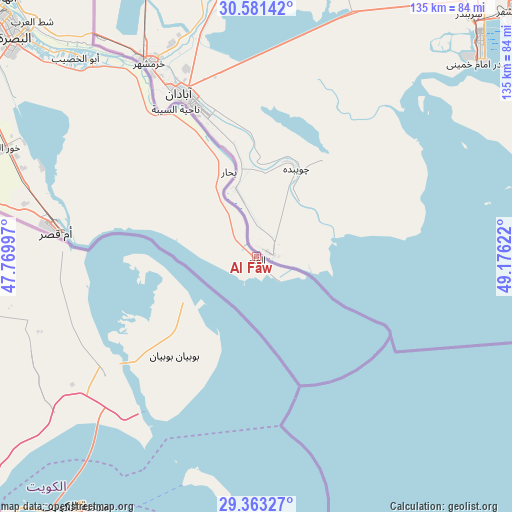
Al Fāw GPS coordinates[2]
29° 58' 27.156" North, 48° 28' 23.124" East
| Map corner | latitude | longitude |
|---|---|---|
| Upper-left | 30.58142°, | 47.76997° |
| Center: | 29.97421°, | 48.47309° |
| Lower-right: | 29.36327°, | 49.17622° |
| Map W x H: | 135.4×135.4 km | = 84.1×84.1mi |
| max Lat: | 37.22781° ⇑100% North |
| Al Fāw: | 29.97421° |
| min Lat: | ⇓0% South 29.97421° |
| min Long | Al Fāw | max Long |
| 40.28586° | 48.47309° | 48.47309° |
| W 100%⇐ | ⇒0% E |
Elevation
Elevation of Al Fāw is 2 m = 7 ft, and this is 291 m = 955 ft below average elevation for this country.
| Max E: |
1316 m = 4318 ft | 99.3% |
| Avg. | 293 m = 961 ft | |
| Al Fāw | 2 m = 7 ft | |
Min E: |
1 m = 3 ft | 0.7% |
See also: Al Fāw elevation on elevation.city.
Geographical zone
Al Fāw is located in North temperate zone (between Tropic of Cancer and the Arctic Circle). Distance of this Northern Tropic circle is 726.9 km =451.7 mi to South.| Distance of | km | miles | from Al Fāw |
|---|---|---|---|
| North Pole | 6674.2 | 4147.2 | to North |
| Arctic Circle | 4068.4 | 2528 | to North |
| Tropic Cancer | 726.9 | 451.7 | to South |
| Equator | 3332.8 | 2070.9 | to South |


Nearby cities:
15 places around Al Fāw: (largest is in red/bold)
• Abī al Khaşīb
70.8 km =44 mi,  317°
317°
• Al Başrah al Qadīmah
86.3 km =53.6 mi,  312°
312°
• Al Hārithah
96.3 km =59.8 mi, 314°
• Al Jabāyish
179 km =111.2 mi, 308°
• Al Kaḩlā’
219.4 km =136.3 mi,  329°
329°
• Al Madīnah
159.3 km =99 mi, 313°
• Al Qurnah
152.7 km =94.9 mi, 319°
• Az Zubayr
87.5 km =54.4 mi,  302°
302°
• Basrah
89.2 km =55.4 mi, 311°
• Nāḩiyat Baḩār
23.6 km =14.7 mi,  342°
342°
• Nāḩiyat al Fuhūd
201 km =124.9 mi, 303°
• Nāḩiyat ‘Atbah
71.6 km =44.5 mi, 321°
• Qal‘at Şāliḩ
206.3 km =128.2 mi, 326°
• Sūq ash Shuyūkh
218.7 km =135.9 mi, 297°
• Umm Qaşr
53.7 km =33.4 mi,  277°
277°
Sources, notices
• [Note1] Compared only with cities in Iraq existing in our database
• [Src1] Map data: © OpenStreetMap contributors (CC-BY-SA)
• [Src2] Other city data from geonames.org with taken over terms of usage.
• [Src3] Geographical zone / Annual Mean Temperature by Robert A. Rohde @ Wikipedia
