Al Jabāyish geodata
Al Jabāyish (Dhi Qar) is a seat of a second-order administrative division; located in Iraq in Asia/Baghdad (GMT+3) time zone. In our database, there are 71 cities with bigger population. Compared to other cities in Iraq, 91.5% of cities are located further ↑North; 90.1% of cities are located further ←West and 99.3% of cities have higher elevation than Al Jabāyish. Note1


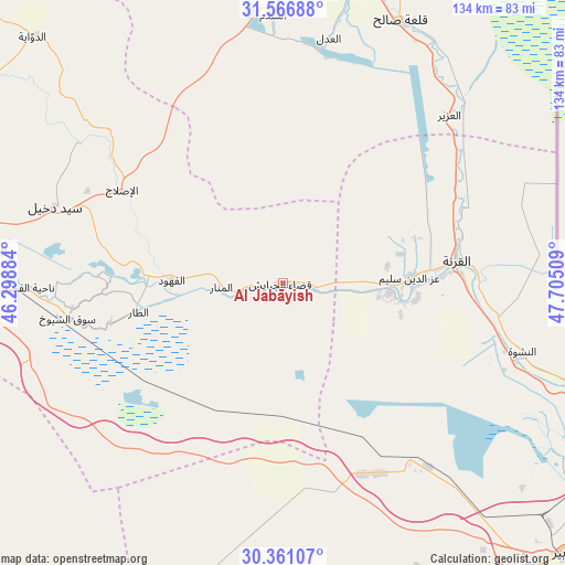
Al Jabāyish GPS coordinates[2]
30° 57' 57.168" North, 47° 0' 7.056" East
| Map corner | latitude | longitude |
|---|---|---|
| Upper-left | 31.56688°, | 46.29884° |
| Center: | 30.96588°, | 47.00196° |
| Lower-right: | 30.36107°, | 47.70509° |
| Map W x H: | 134.1×134.1 km | = 83.3×83.3mi |
| max Lat: | 37.22781° ⇑91.5% North |
| Al Jabāyish: | 30.96588° |
| min Lat: | ⇓8.5% South 29.97421° |
| min Long | Al Jabāyish | max Long |
| 40.28586° | 47.00196° | 48.47309° |
| W 90.1%⇐ | ⇒9.9% E |
Elevation
Elevation of Al Jabāyish is 2 m = 7 ft, and this is 291 m = 955 ft below average elevation for this country.
| Max E: |
1316 m = 4318 ft | 99.3% |
| Avg. | 293 m = 961 ft | |
| Al Jabāyish | 2 m = 7 ft | |
Min E: |
1 m = 3 ft | 0.7% |
See also: Iraq elevation on elevation.city.
Geographical zone
Al Jabāyish is located in North temperate zone (between Tropic of Cancer and the Arctic Circle). Distance of this Northern Tropic circle is 837.2 km =520.2 mi to South.| Distance of | km | miles | from Al Jabāyish |
|---|---|---|---|
| North Pole | 6564 | 4078.7 | to North |
| Arctic Circle | 3958.1 | 2459.4 | to North |
| Tropic Cancer | 837.2 | 520.2 | to South |
| Equator | 3443.1 | 2139.4 | to South |


Nearby cities:
15 places around Al Jabāyish: (largest is in red/bold)
• Abī al Khaşīb
109.8 km =68.2 mi,  121°
121°
• Al Başrah al Qadīmah
93.2 km =57.9 mi, 123°
• Al Hārithah
84 km =52.2 mi, 120°
• Al Kaḩlā’
82.9 km =51.5 mi,  19°
19°
• Al Madīnah
25.6 km =15.9 mi,  90°
90°
• Al Maymūnah
79.4 km =49.3 mi,  357°
357°
• Al Qurnah
41.5 km =25.8 mi,  82°
82°
• Al ‘Amārah
97.7 km =60.7 mi,  7°
7°
• Ash Shaţrah
93 km =57.8 mi,  301°
301°
• Az Zubayr
92.5 km =57.5 mi,  133°
133°
• Basrah
90.1 km =56 mi, 124°
• Nasiriyah
71.7 km =44.6 mi,  278°
278°
• Nāḩiyat al Fuhūd
26.6 km =16.5 mi,  270°
270°
• Qal‘at Şāliḩ
68.4 km =42.5 mi, 23°
• Sūq ash Shuyūkh
52.9 km =32.9 mi,  260°
260°
Sources, notices
• [Note1] Compared only with cities in Iraq existing in our database
• [Src1] Map data: © OpenStreetMap contributors (CC-BY-SA)
• [Src2] Other city data from geonames.org with taken over terms of usage.
• [Src3] Geographical zone / Annual Mean Temperature by Robert A. Rohde @ Wikipedia
