Vallermosa geodata
Vallermosa (Sardinia) is a seat of a third-order administrative division; located in Italy in Europe/Rome (GMT+2) time zone. With population of 1,593 people, there are 4924 cities with bigger population in this country. Compared to other cities in Italy, 90.9% of cities are located further ↑North; 84.2% of cities are located further →East and 74.9% of cities have higher elevation than Vallermosa. Note1
Administrative division(s):
- Level 1: Sardinia
- Level 2: Provincia del Sud Sardegna
- Level 3: Vallermosa


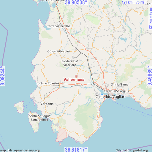
Vallermosa GPS coordinates[2]
39° 21' 50.004" North, 8° 47' 44.016" East
| Map corner | latitude | longitude |
|---|---|---|
| Upper-left | 39.90538°, | 8.09244° |
| Center: | 39.36389°, | 8.79556° |
| Lower-right: | 38.81817°, | 9.49869° |
| Map W x H: | 120.9×120.9 km | = 75.1×75.1mi |
| max Lat: | 47.04031° ⇑90.9% North |
| Vallermosa: | 39.36389° |
| min Lat: | ⇓9.1% South 35.50142° |
| min Long | Vallermosa | max Long |
| 6.69888° | 8.79556° | 18.48682° |
| W 15.8%⇐ | ⇒84.2% E |
Elevation
Elevation of Vallermosa is 74 m = 243 ft, and this is 232.7 m = 763 ft below average elevation for this country.
| Max E: |
2085 m = 6841 ft | 74.9% |
| Avg. | 306.7 m = 1006 ft | |
| Vallermosa | 74 m = 243 ft | |
Min E: |
-4 m = -13 ft | 25.1% |
See also: Italy elevation on elevation.city.
Geographical zone
Vallermosa is located in North temperate zone (between Tropic of Cancer and the Arctic Circle). Distance of this Northern Tropic circle is 1770.9 km =1100.4 mi to South.| Distance of | km | miles | from Vallermosa |
|---|---|---|---|
| North Pole | 5630.2 | 3498.4 | to North |
| Arctic Circle | 3024.3 | 1879.2 | to North |
| Tropic Cancer | 1770.9 | 1100.4 | to South |
| Equator | 4376.9 | 2719.7 | to South |


Nearby cities:
15 places around Vallermosa: (largest is in red/bold)
• Assemini
19.3 km =12 mi,  114°
114°
• Decimomannu
16.1 km =10 mi, 111°
• Decimoputzu
10.7 km =6.6 mi, 107°
• Domusnovas
13.3 km =8.3 mi,  250°
250°
• Gonnosfanadiga
18.5 km =11.5 mi,  321°
321°
• Musei
13.1 km =8.1 mi,  238°
238°
• Samassi
16.2 km =10.1 mi,  35°
35°
• San Sperate
18.3 km =11.4 mi,  92°
92°
• Serramanna
12.7 km =7.9 mi,  58°
58°
• Siliqua
7 km =4.3 mi,  172°
172°
• Uta
15.7 km =9.8 mi,  120°
120°
• Villacidro
11.4 km =7.1 mi,  335°
335°
• Villamassargia
16.6 km =10.3 mi,  233°
233°
• Villasor
12.8 km =8 mi,  81°
81°
• Villaspeciosa
12.6 km =7.8 mi, 117°
Sources, notices
• [Note1] Compared only with cities in Italy existing in our database
• [Src1] Map data: © OpenStreetMap contributors (CC-BY-SA)
• [Src2] Other city data from geonames.org with taken over terms of usage.
• [Src3] Geographical zone / Annual Mean Temperature by Robert A. Rohde @ Wikipedia
