Samassi geodata
Samassi (Sardinia) is a seat of a third-order administrative division; located in Italy in Europe/Rome (GMT+2) time zone. With population of 5,321 people, there are 1835 cities with bigger population in this country. Compared to other cities in Italy, 90.5% of cities are located further ↑North; 82.6% of cities are located further →East and 79% of cities have higher elevation than Samassi. Note1


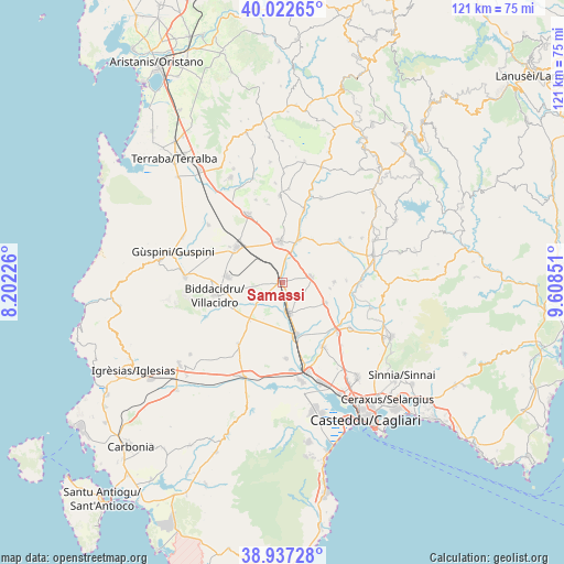
Samassi GPS coordinates[2]
39° 28' 55.488" North, 8° 54' 19.368" East
| Map corner | latitude | longitude |
|---|---|---|
| Upper-left | 40.02265°, | 8.20226° |
| Center: | 39.48208°, | 8.90538° |
| Lower-right: | 38.93728°, | 9.60851° |
| Map W x H: | 120.7×120.7 km | = 75×75mi |
| max Lat: | 47.04031° ⇑90.5% North |
| Samassi: | 39.48208° |
| min Lat: | ⇓9.5% South 35.50142° |
| min Long | Samassi | max Long |
| 6.69888° | 8.90538° | 18.48682° |
| W 17.4%⇐ | ⇒82.6% E |
Elevation
Elevation of Samassi is 54 m = 177 ft, and this is 252.7 m = 829 ft below average elevation for this country.
| Max E: |
2085 m = 6841 ft | 79% |
| Avg. | 306.7 m = 1006 ft | |
| Samassi | 54 m = 177 ft | |
Min E: |
-4 m = -13 ft | 21% |
See also: Italy elevation on elevation.city.
Geographical zone
Samassi is located in North temperate zone (between Tropic of Cancer and the Arctic Circle). Distance of this Northern Tropic circle is 1784.1 km =1108.6 mi to South.| Distance of | km | miles | from Samassi |
|---|---|---|---|
| North Pole | 5617.1 | 3490.3 | to North |
| Arctic Circle | 3011.2 | 1871.1 | to North |
| Tropic Cancer | 1784.1 | 1108.6 | to South |
| Equator | 4390 | 2727.8 | to South |


Nearby cities:
15 places around Samassi: (largest is in red/bold)
• Furtei
9.7 km =6 mi,  22°
22°
• Guasila
14.7 km =9.1 mi,  53°
53°
• Monastir
16.2 km =10.1 mi,  132°
132°
• Nuraminis
10.3 km =6.4 mi,  115°
115°
• Pimentel
13.7 km =8.5 mi,  87°
87°
• Samatzai
11.1 km =6.9 mi, 89°
• San Gavino Monreale
12.4 km =7.7 mi,  307°
307°
• Sanluri
8.9 km =5.5 mi,  356°
356°
• Segariu
11.2 km =7 mi,  35°
35°
• Serramanna
6.7 km =4.2 mi,  167°
167°
• Serrenti
6.2 km =3.9 mi,  78°
78°
• Vallermosa
16.2 km =10.1 mi,  215°
215°
• Villacidro
14.4 km =8.9 mi,  258°
258°
• Villamar
15.9 km =9.9 mi, 16°
• Villasor
11.7 km =7.3 mi,  164°
164°
Sources, notices
• [Note1] Compared only with cities in Italy existing in our database
• [Src1] Map data: © OpenStreetMap contributors (CC-BY-SA)
• [Src2] Other city data from geonames.org with taken over terms of usage.
• [Src3] Geographical zone / Annual Mean Temperature by Robert A. Rohde @ Wikipedia
