Vallelonga geodata
Vallelonga (Calabria) is a seat of a third-order administrative division; located in Italy in Europe/Rome (GMT+2) time zone. With population of 455 people, there are 10074 cities with bigger population in this country. Compared to other cities in Italy, 93.6% of cities are located further ↑North; 95.2% of cities are located further ←West and 87.5% of cities have lower elevation than Vallelonga. Note1
Administrative division(s):
- Level 1: Calabria
- Level 2: Provincia di Vibo-Valentia
- Level 3: Vallelonga


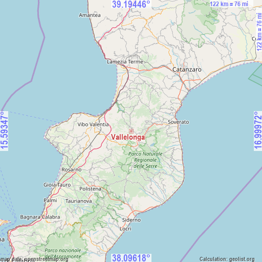
Vallelonga GPS coordinates[2]
38° 38' 50.712" North, 16° 17' 47.724" East
| Map corner | latitude | longitude |
|---|---|---|
| Upper-left | 39.19446°, | 15.59347° |
| Center: | 38.64742°, | 16.29659° |
| Lower-right: | 38.09618°, | 16.99972° |
| Map W x H: | 122.1×122.1 km | = 75.9×75.9mi |
| max Lat: | 47.04031° ⇑93.6% North |
| Vallelonga: | 38.64742° |
| min Lat: | ⇓6.4% South 35.50142° |
| min Long | Vallelonga | max Long |
| 6.69888° | 16.29659° | 18.48682° |
| W 95.2%⇐ | ⇒4.8% E |
Elevation
Elevation of Vallelonga is 662 m = 2172 ft, and this is 355.3 m = 1166 ft above average elevation for this country.
| Max E: |
2085 m = 6841 ft | 12.5% |
| Vallelonga | 662 m 2172 ft | |
| Avg. | 306.7 m = 1006 ft | |
Min E: |
-4 m = -13 ft | 87.5% |
See also: Italy elevation on elevation.city.
Geographical zone
Vallelonga is located in North temperate zone (between Tropic of Cancer and the Arctic Circle). Distance of this Northern Tropic circle is 1691.3 km =1050.9 mi to South.| Distance of | km | miles | from Vallelonga |
|---|---|---|---|
| North Pole | 5709.9 | 3548 | to North |
| Arctic Circle | 3104 | 1928.7 | to North |
| Tropic Cancer | 1691.3 | 1050.9 | to South |
| Equator | 4297.2 | 2670.2 | to South |


Nearby cities:
15 places around Vallelonga: (largest is in red/bold)
• Brognaturo
6.4 km =4 mi,  142°
142°
• Capistrano
4.9 km =3 mi,  352°
352°
• Cardinale
7.9 km =4.9 mi,  84°
84°
• Filogaso
7.3 km =4.5 mi,  302°
302°
• Gerocarne
9.5 km =5.9 mi,  225°
225°
• Monterosso Calabro
7.8 km =4.8 mi,  356°
356°
• Pizzoni
5 km =3.1 mi,  236°
236°
• San Nicola da Crissa
2 km =1.2 mi,  332°
332°
• Serra San Bruno
8.5 km =5.3 mi,  162°
162°
• Simbario
5.3 km =3.3 mi, 139°
• Sorianello
8.2 km =5.1 mi,  223°
223°
• Soriano Calabro
8.3 km =5.2 mi, 231°
• Spadola
6 km =3.7 mi, 144°
• Torre di Ruggiero
6.6 km =4.1 mi, 84°
• Vazzano
4.5 km =2.8 mi,  249°
249°
Sources, notices
• [Note1] Compared only with cities in Italy existing in our database
• [Src1] Map data: © OpenStreetMap contributors (CC-BY-SA)
• [Src2] Other city data from geonames.org with taken over terms of usage.
• [Src3] Geographical zone / Annual Mean Temperature by Robert A. Rohde @ Wikipedia
