Filogaso geodata
Filogaso (Calabria) is a seat of a third-order administrative division; located in Italy in Europe/Rome (GMT+2) time zone. With population of 1,353 people, there are 5483 cities with bigger population in this country. Compared to other cities in Italy, 93.4% of cities are located further ↑North; 94.6% of cities are located further ←West and 57.5% of cities have lower elevation than Filogaso. Note1


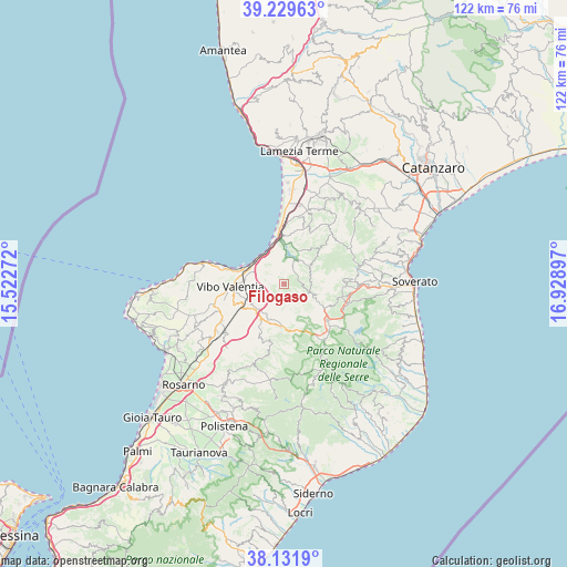
Filogaso GPS coordinates[2]
38° 40' 58.332" North, 16° 13' 33.024" East
| Map corner | latitude | longitude |
|---|---|---|
| Upper-left | 39.22963°, | 15.52272° |
| Center: | 38.68287°, | 16.22584° |
| Lower-right: | 38.1319°, | 16.92897° |
| Map W x H: | 122.1×122.1 km | = 75.9×75.9mi |
| max Lat: | 47.04031° ⇑93.4% North |
| Filogaso: | 38.68287° |
| min Lat: | ⇓6.6% South 35.50142° |
| min Long | Filogaso | max Long |
| 6.69888° | 16.22584° | 18.48682° |
| W 94.6%⇐ | ⇒5.4% E |
Elevation
Elevation of Filogaso is 282 m = 925 ft, and this is 24.7 m = 81 ft below average elevation for this country.
| Max E: |
2085 m = 6841 ft | 42.5% |
| Avg. | 306.7 m = 1006 ft | |
| Filogaso | 282 m = 925 ft | |
Min E: |
-4 m = -13 ft | 57.5% |
See also: Italy elevation on elevation.city.
Geographical zone
Filogaso is located in North temperate zone (between Tropic of Cancer and the Arctic Circle). Distance of this Northern Tropic circle is 1695.2 km =1053.3 mi to South.| Distance of | km | miles | from Filogaso |
|---|---|---|---|
| North Pole | 5705.9 | 3545.5 | to North |
| Arctic Circle | 3100 | 1926.3 | to North |
| Tropic Cancer | 1695.2 | 1053.3 | to South |
| Equator | 4301.1 | 2672.6 | to South |


Nearby cities:
15 places around Filogaso: (largest is in red/bold)
• Capistrano
5.6 km =3.5 mi,  80°
80°
• Gerocarne
10.6 km =6.6 mi,  183°
183°
• Longobardi
9.4 km =5.8 mi,  284°
284°
• Maierato
5.4 km =3.4 mi,  305°
305°
• Monterosso Calabro
6.8 km =4.2 mi,  55°
55°
• Piscopio
10.2 km =6.3 mi,  257°
257°
• Pizzo
8.5 km =5.3 mi,  336°
336°
• Pizzoni
7 km =4.3 mi,  163°
163°
• San Nicola da Crissa
5.6 km =3.5 mi,  112°
112°
• Sant'Onofrio
7 km =4.3 mi, 283°
• Sorianello
9.9 km =6.2 mi, 176°
• Soriano Calabro
9.2 km =5.7 mi, 182°
• Stefanaconi
8.8 km =5.5 mi,  266°
266°
• Vallelonga
7.3 km =4.5 mi,  122°
122°
• Vazzano
5.9 km =3.7 mi, 160°
Sources, notices
• [Note1] Compared only with cities in Italy existing in our database
• [Src1] Map data: © OpenStreetMap contributors (CC-BY-SA)
• [Src2] Other city data from geonames.org with taken over terms of usage.
• [Src3] Geographical zone / Annual Mean Temperature by Robert A. Rohde @ Wikipedia
