Gerocarne geodata
Gerocarne (Calabria) is a seat of a third-order administrative division; located in Italy in Europe/Rome (GMT+2) time zone. With population of 947 people, there are 6873 cities with bigger population in this country. Compared to other cities in Italy, 93.9% of cities are located further ↑North; 94.6% of cities are located further ←West and 51.2% of cities have lower elevation than Gerocarne. Note1
Administrative division(s):
- Level 1: Calabria
- Level 2: Provincia di Vibo-Valentia
- Level 3: Gerocarne


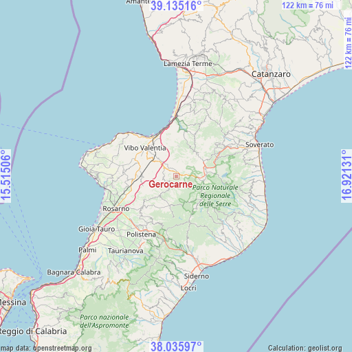
Gerocarne GPS coordinates[2]
38° 35' 15.612" North, 16° 13' 5.448" East
| Map corner | latitude | longitude |
|---|---|---|
| Upper-left | 39.13516°, | 15.51506° |
| Center: | 38.58767°, | 16.21818° |
| Lower-right: | 38.03597°, | 16.92131° |
| Map W x H: | 122.2×122.2 km | = 75.9×75.9mi |
| max Lat: | 47.04031° ⇑93.9% North |
| Gerocarne: | 38.58767° |
| min Lat: | ⇓6.1% South 35.50142° |
| min Long | Gerocarne | max Long |
| 6.69888° | 16.21818° | 18.48682° |
| W 94.6%⇐ | ⇒5.4% E |
Elevation
Elevation of Gerocarne is 242 m = 794 ft, and this is 64.7 m = 212 ft below average elevation for this country.
| Max E: |
2085 m = 6841 ft | 48.8% |
| Avg. | 306.7 m = 1006 ft | |
| Gerocarne | 242 m = 794 ft | |
Min E: |
-4 m = -13 ft | 51.2% |
See also: Italy elevation on elevation.city.
Geographical zone
Gerocarne is located in North temperate zone (between Tropic of Cancer and the Arctic Circle). Distance of this Northern Tropic circle is 1684.6 km =1046.8 mi to South.| Distance of | km | miles | from Gerocarne |
|---|---|---|---|
| North Pole | 5716.5 | 3552.1 | to North |
| Arctic Circle | 3110.6 | 1932.8 | to North |
| Tropic Cancer | 1684.6 | 1046.8 | to South |
| Equator | 4290.5 | 2666 | to South |


Nearby cities:
15 places around Gerocarne: (largest is in red/bold)
• Acquaro
4.3 km =2.7 mi,  218°
218°
• Arena
2.9 km =1.8 mi,  193°
193°
• Dasà
3.2 km =2 mi, 218°
• Dinami
9 km =5.6 mi,  225°
225°
• Melicuccà
7.7 km =4.8 mi, 223°
• Monsoreto
9.2 km =5.7 mi,  209°
209°
• Pizzoni
4.7 km =2.9 mi,  34°
34°
• San Nicola da Crissa
10.3 km =6.4 mi, 34°
• San Pietro di Caridà
10.1 km =6.3 mi, 225°
• Serra San Bruno
9.5 km =5.9 mi,  98°
98°
• Sorianello
1.4 km =0.9 mi,  59°
59°
• Soriano Calabro
1.5 km =0.9 mi,  13°
13°
• Spadola
10.5 km =6.5 mi,  80°
80°
• Vallelonga
9.5 km =5.9 mi,  45°
45°
• Vazzano
5.7 km =3.5 mi, 27°
Sources, notices
• [Note1] Compared only with cities in Italy existing in our database
• [Src1] Map data: © OpenStreetMap contributors (CC-BY-SA)
• [Src2] Other city data from geonames.org with taken over terms of usage.
• [Src3] Geographical zone / Annual Mean Temperature by Robert A. Rohde @ Wikipedia
