Simaxis geodata
Simaxis (Sardinia) is a seat of a third-order administrative division; located in Italy in Europe/Rome (GMT+2) time zone. With population of 2,074 people, there are 4029 cities with bigger population in this country. Compared to other cities in Italy, 88.4% of cities are located further ↑North; 85.6% of cities are located further →East and 90.1% of cities have higher elevation than Simaxis. Note1


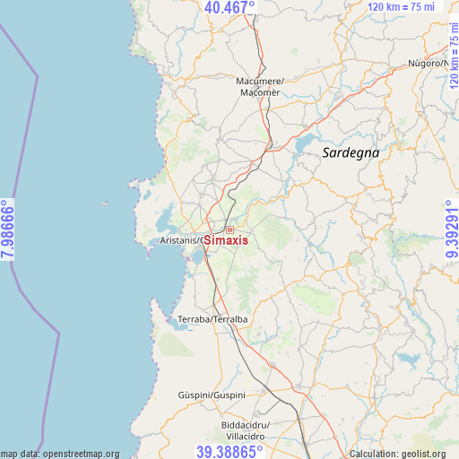
Simaxis GPS coordinates[2]
39° 55' 47.82" North, 8° 41' 23.244" East
| Map corner | latitude | longitude |
|---|---|---|
| Upper-left | 40.467°, | 7.98666° |
| Center: | 39.92995°, | 8.68979° |
| Lower-right: | 39.38865°, | 9.39291° |
| Map W x H: | 119.9×119.9 km | = 74.5×74.5mi |
| max Lat: | 47.04031° ⇑88.4% North |
| Simaxis: | 39.92995° |
| min Lat: | ⇓11.6% South 35.50142° |
| min Long | Simaxis | max Long |
| 6.69888° | 8.68979° | 18.48682° |
| W 14.4%⇐ | ⇒85.6% E |
Elevation
Elevation of Simaxis is 18 m = 59 ft, and this is 288.7 m = 947 ft below average elevation for this country.
| Max E: |
2085 m = 6841 ft | 90.1% |
| Avg. | 306.7 m = 1006 ft | |
| Simaxis | 18 m = 59 ft | |
Min E: |
-4 m = -13 ft | 9.9% |
See also: Italy elevation on elevation.city.
Geographical zone
Simaxis is located in North temperate zone (between Tropic of Cancer and the Arctic Circle). Distance of this Northern Tropic circle is 1833.9 km =1139.5 mi to South.| Distance of | km | miles | from Simaxis |
|---|---|---|---|
| North Pole | 5567.3 | 3459.4 | to North |
| Arctic Circle | 2961.4 | 1840.1 | to North |
| Tropic Cancer | 1833.9 | 1139.5 | to South |
| Equator | 4439.8 | 2758.8 | to South |


Nearby cities:
15 places around Simaxis: (largest is in red/bold)
• Donigala Fenugheddu
10 km =6.2 mi,  273°
273°
• Nuraxinieddu
7.8 km =4.8 mi,  276°
276°
• Ollastra
4.5 km =2.8 mi,  58°
58°
• Oristano
8.8 km =5.5 mi,  250°
250°
• Palmas Arborea
7.1 km =4.4 mi,  213°
213°
• Santa Giusta
8.8 km =5.5 mi,  231°
231°
• Siamaggiore
5.2 km =3.2 mi,  294°
294°
• Siamanna
6.3 km =3.9 mi,  100°
100°
• Siapiccia
6.2 km =3.9 mi,  92°
92°
• Silì
5.9 km =3.7 mi,  256°
256°
• Solarussa
3.1 km =1.9 mi,  334°
334°
• Tramatza
8.8 km =5.5 mi,  337°
337°
• Villanova Truschedu
8.4 km =5.2 mi,  39°
39°
• Villaurbana
9.1 km =5.7 mi,  123°
123°
• Zerfaliu
3.8 km =2.4 mi,  26°
26°
Sources, notices
• [Note1] Compared only with cities in Italy existing in our database
• [Src1] Map data: © OpenStreetMap contributors (CC-BY-SA)
• [Src2] Other city data from geonames.org with taken over terms of usage.
• [Src3] Geographical zone / Annual Mean Temperature by Robert A. Rohde @ Wikipedia
