Palmas Arborea geodata
Palmas Arborea (Sardinia) is a seat of a third-order administrative division; located in Italy in Europe/Rome (GMT+2) time zone. With population of 1,092 people, there are 6320 cities with bigger population in this country. Compared to other cities in Italy, 88.7% of cities are located further ↑North; 86.2% of cities are located further →East and 93% of cities have higher elevation than Palmas Arborea. Note1
Administrative division(s):
- Level 1: Sardinia
- Level 2: Provincia di Oristano
- Level 3: Palmas Arborea


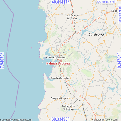
Palmas Arborea GPS coordinates[2]
39° 52' 36.12" North, 8° 38' 38.076" East
| Map corner | latitude | longitude |
|---|---|---|
| Upper-left | 40.41417°, | 7.94079° |
| Center: | 39.8767°, | 8.64391° |
| Lower-right: | 39.33498°, | 9.34704° |
| Map W x H: | 120×120 km | = 74.6×74.6mi |
| max Lat: | 47.04031° ⇑88.7% North |
| Palmas Arborea: | 39.8767° |
| min Lat: | ⇓11.3% South 35.50142° |
| min Long | Palmas Arborea | max Long |
| 6.69888° | 8.64391° | 18.48682° |
| W 13.8%⇐ | ⇒86.2% E |
Elevation
Elevation of Palmas Arborea is 12 m = 39 ft, and this is 294.7 m = 967 ft below average elevation for this country.
| Max E: |
2085 m = 6841 ft | 93% |
| Avg. | 306.7 m = 1006 ft | |
| Palmas Arborea | 12 m = 39 ft | |
Min E: |
-4 m = -13 ft | 7% |
See also: Italy elevation on elevation.city.
Geographical zone
Palmas Arborea is located in North temperate zone (between Tropic of Cancer and the Arctic Circle). Distance of this Northern Tropic circle is 1828 km =1135.9 mi to South.| Distance of | km | miles | from Palmas Arborea |
|---|---|---|---|
| North Pole | 5573.2 | 3463 | to North |
| Arctic Circle | 2967.3 | 1843.8 | to North |
| Tropic Cancer | 1828 | 1135.9 | to South |
| Equator | 4433.9 | 2755.1 | to South |


Nearby cities:
15 places around Palmas Arborea: (largest is in red/bold)
• Cabras
11.1 km =6.9 mi,  301°
301°
• Donigala Fenugheddu
8.9 km =5.5 mi,  317°
317°
• Nuraxinieddu
7.9 km =4.9 mi,  330°
330°
• Ollastra
11.3 km =7 mi,  43°
43°
• Oristano
5.3 km =3.3 mi, 304°
• Santa Giusta
3 km =1.9 mi,  278°
278°
• Siamaggiore
8.2 km =5.1 mi,  354°
354°
• Siamanna
11.1 km =6.9 mi,  64°
64°
• Siapiccia
11.6 km =7.2 mi, 60°
• Silì
4.9 km =3 mi,  337°
337°
• Simaxis
7.1 km =4.4 mi,  33°
33°
• Solanas
9.8 km =6.1 mi,  307°
307°
• Solarussa
9.1 km =5.7 mi,  16°
16°
• Villaurbana
11.5 km =7.1 mi,  85°
85°
• Zerfaliu
10.9 km =6.8 mi, 30°
Sources, notices
• [Note1] Compared only with cities in Italy existing in our database
• [Src1] Map data: © OpenStreetMap contributors (CC-BY-SA)
• [Src2] Other city data from geonames.org with taken over terms of usage.
• [Src3] Geographical zone / Annual Mean Temperature by Robert A. Rohde @ Wikipedia
