Siamaggiore geodata
Siamaggiore (Sardinia) is a seat of a third-order administrative division; located in Italy in Europe/Rome (GMT+2) time zone. With population of 670 people, there are 8485 cities with bigger population in this country. Compared to other cities in Italy, 88.3% of cities are located further ↑North; 86.3% of cities are located further →East and 90.6% of cities have higher elevation than Siamaggiore. Note1


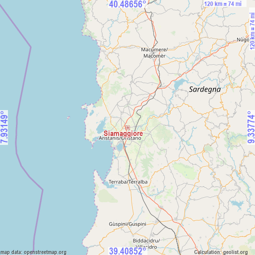
Siamaggiore GPS coordinates[2]
39° 56' 58.776" North, 8° 38' 4.596" East
| Map corner | latitude | longitude |
|---|---|---|
| Upper-left | 40.48656°, | 7.93149° |
| Center: | 39.94966°, | 8.63461° |
| Lower-right: | 39.40852°, | 9.33774° |
| Map W x H: | 119.9×119.9 km | = 74.5×74.5mi |
| max Lat: | 47.04031° ⇑88.3% North |
| Siamaggiore: | 39.94966° |
| min Lat: | ⇓11.7% South 35.50142° |
| min Long | Siamaggiore | max Long |
| 6.69888° | 8.63461° | 18.48682° |
| W 13.7%⇐ | ⇒86.3% E |
Elevation
Elevation of Siamaggiore is 17 m = 56 ft, and this is 289.7 m = 950 ft below average elevation for this country.
| Max E: |
2085 m = 6841 ft | 90.6% |
| Avg. | 306.7 m = 1006 ft | |
| Siamaggiore | 17 m = 56 ft | |
Min E: |
-4 m = -13 ft | 9.4% |
See also: Italy elevation on elevation.city.
Geographical zone
Siamaggiore is located in North temperate zone (between Tropic of Cancer and the Arctic Circle). Distance of this Northern Tropic circle is 1836.1 km =1140.9 mi to South.| Distance of | km | miles | from Siamaggiore |
|---|---|---|---|
| North Pole | 5565.1 | 3458 | to North |
| Arctic Circle | 2959.2 | 1838.8 | to North |
| Tropic Cancer | 1836.1 | 1140.9 | to South |
| Equator | 4442 | 2760.1 | to South |


Nearby cities:
15 places around Siamaggiore: (largest is in red/bold)
• Baratili San Pietro
8.2 km =5.1 mi,  305°
305°
• Bauladu
8.5 km =5.3 mi,  21°
21°
• Donigala Fenugheddu
5.5 km =3.4 mi,  252°
252°
• Nuraxinieddu
3.3 km =2.1 mi, 247°
• Oristano
6.3 km =3.9 mi,  214°
214°
• Palmas Arborea
8.2 km =5.1 mi,  174°
174°
• San Vero Milis
7.8 km =4.8 mi,  336°
336°
• Santa Giusta
8 km =5 mi,  195°
195°
• Silì
3.7 km =2.3 mi, 197°
• Simaxis
5.2 km =3.2 mi,  114°
114°
• Solanas
7.2 km =4.5 mi, 252°
• Solarussa
3.4 km =2.1 mi,  79°
79°
• Tramatza
6.1 km =3.8 mi,  12°
12°
• Zeddiani
5.5 km =3.4 mi,  322°
322°
• Zerfaliu
6.5 km =4 mi, 78°
Sources, notices
• [Note1] Compared only with cities in Italy existing in our database
• [Src1] Map data: © OpenStreetMap contributors (CC-BY-SA)
• [Src2] Other city data from geonames.org with taken over terms of usage.
• [Src3] Geographical zone / Annual Mean Temperature by Robert A. Rohde @ Wikipedia
