Sferracavallo geodata
Sferracavallo (Sicily) is a populated place; located in Italy in Europe/Rome (GMT+2) time zone. With population of 7,800 people, there are 1248 cities with bigger population in this country. Compared to other cities in Italy, 95% of cities are located further ↑North; 71.2% of cities are located further ←West and 89.6% of cities have higher elevation than Sferracavallo. Note1
Administrative division(s):
- Level 1: Sicily
- Level 2: Palermo
- Level 3: Palermo
- Level 4: Circoscrizione VII


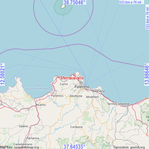
Sferracavallo GPS coordinates[2]
38° 12' 0" North, 13° 16' 59.988" East
| Map corner | latitude | longitude |
|---|---|---|
| Upper-left | 38.75046°, | 12.58021° |
| Center: | 38.2°, | 13.28333° |
| Lower-right: | 37.64535°, | 13.98646° |
| Map W x H: | 122.9×122.9 km | = 76.4×76.4mi |
| max Lat: | 47.04031° ⇑95% North |
| Sferracavallo: | 38.2° |
| min Lat: | ⇓5% South 35.50142° |
| min Long | Sferracavallo | max Long |
| 6.69888° | 13.28333° | 18.48682° |
| W 71.2%⇐ | ⇒28.8% E |
Elevation
Elevation of Sferracavallo is 19 m = 62 ft, and this is 287.7 m = 944 ft below average elevation for this country.
| Max E: |
2085 m = 6841 ft | 89.6% |
| Avg. | 306.7 m = 1006 ft | |
| Sferracavallo | 19 m = 62 ft | |
Min E: |
-4 m = -13 ft | 10.4% |
See also: Italy elevation on elevation.city.
Geographical zone
Sferracavallo is located in North temperate zone (between Tropic of Cancer and the Arctic Circle). Distance of this Northern Tropic circle is 1641.5 km =1020 mi to South.| Distance of | km | miles | from Sferracavallo |
|---|---|---|---|
| North Pole | 5759.6 | 3578.8 | to North |
| Arctic Circle | 3153.7 | 1959.6 | to North |
| Tropic Cancer | 1641.5 | 1020 | to South |
| Equator | 4247.4 | 2639.2 | to South |


Nearby cities:
15 places around Sferracavallo: (largest is in red/bold)
• Bellolampo
7.2 km =4.5 mi,  187°
187°
• Cannizzaro-Favara
15.4 km =9.6 mi,  183°
183°
• Capaci
5 km =3.1 mi,  230°
230°
• Carini
11.6 km =7.2 mi, 229°
• Cinisi
16.5 km =10.3 mi,  254°
254°
• Giardinello
16.8 km =10.4 mi,  221°
221°
• Isola delle Femmine
3.3 km =2.1 mi, 252°
• Monreale
13.2 km =8.2 mi, 177°
• Montelepre
15.4 km =9.6 mi, 217°
• Palermo
8.8 km =5.5 mi,  148°
148°
• Piano Maglio-Blandino
16 km =9.9 mi,  171°
171°
• Piano dei Geli
11.2 km =7 mi, 183°
• San Martino delle Scale
12.4 km =7.7 mi, 191°
• Torretta
8.8 km =5.5 mi,  208°
208°
• Villa Ciambra
15.8 km =9.8 mi, 168°
Sources, notices
• [Note1] Compared only with cities in Italy existing in our database
• [Src1] Map data: © OpenStreetMap contributors (CC-BY-SA)
• [Src2] Other city data from geonames.org with taken over terms of usage.
• [Src3] Geographical zone / Annual Mean Temperature by Robert A. Rohde @ Wikipedia
