Cinisi geodata
Cinisi (Sicily) is a seat of a third-order administrative division; located in Italy in Europe/Rome (GMT+2) time zone. With population of 11,704 people, there are 798 cities with bigger population in this country. Compared to other cities in Italy, 95.3% of cities are located further ↑North; 69.4% of cities are located further ←West and 79.9% of cities have higher elevation than Cinisi. Note1


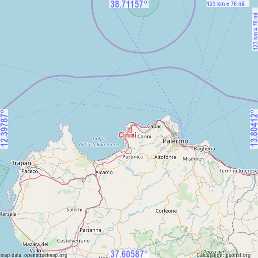
Cinisi GPS coordinates[2]
38° 9' 38.952" North, 13° 6' 3.564" East
| Map corner | latitude | longitude |
|---|---|---|
| Upper-left | 38.71157°, | 12.39787° |
| Center: | 38.16082°, | 13.10099° |
| Lower-right: | 37.60587°, | 13.80412° |
| Map W x H: | 122.9×122.9 km | = 76.4×76.4mi |
| max Lat: | 47.04031° ⇑95.3% North |
| Cinisi: | 38.16082° |
| min Lat: | ⇓4.7% South 35.50142° |
| min Long | Cinisi | max Long |
| 6.69888° | 13.10099° | 18.48682° |
| W 69.4%⇐ | ⇒30.6% E |
Elevation
Elevation of Cinisi is 50 m = 164 ft, and this is 256.7 m = 842 ft below average elevation for this country.
| Max E: |
2085 m = 6841 ft | 79.9% |
| Avg. | 306.7 m = 1006 ft | |
| Cinisi | 50 m = 164 ft | |
Min E: |
-4 m = -13 ft | 20.1% |
See also: Italy elevation on elevation.city.
Geographical zone
Cinisi is located in North temperate zone (between Tropic of Cancer and the Arctic Circle). Distance of this Northern Tropic circle is 1637.2 km =1017.3 mi to South.| Distance of | km | miles | from Cinisi |
|---|---|---|---|
| North Pole | 5764 | 3581.6 | to North |
| Arctic Circle | 3158.1 | 1962.4 | to North |
| Tropic Cancer | 1637.2 | 1017.3 | to South |
| Equator | 4243.1 | 2636.5 | to South |


Nearby cities:
15 places around Cinisi: (largest is in red/bold)
• Agliandroni-Paternella
4.2 km =2.6 mi,  222°
222°
• Balestrate
14.7 km =9.1 mi,  213°
213°
• Bellolampo
15.2 km =9.4 mi,  100°
100°
• Borgetto
13.2 km =8.2 mi,  164°
164°
• Capaci
12.1 km =7.5 mi,  84°
84°
• Carini
7.8 km =4.8 mi,  113°
113°
• Giardinello
9.5 km =5.9 mi,  149°
149°
• Isola delle Femmine
13.2 km =8.2 mi, 75°
• Montelepre
10.2 km =6.3 mi,  140°
140°
• Partinico
12.8 km =8 mi,  173°
173°
• San Martino delle Scale
15.5 km =9.6 mi,  120°
120°
• Sferracavallo
16.5 km =10.3 mi,  74°
74°
• Terrasini
2.2 km =1.4 mi, 223°
• Torretta
12.2 km =7.6 mi, 106°
• Trappeto
11.6 km =7.2 mi, 208°
Sources, notices
• [Note1] Compared only with cities in Italy existing in our database
• [Src1] Map data: © OpenStreetMap contributors (CC-BY-SA)
• [Src2] Other city data from geonames.org with taken over terms of usage.
• [Src3] Geographical zone / Annual Mean Temperature by Robert A. Rohde @ Wikipedia
