Serdiana geodata
Serdiana (Sardinia) is a seat of a third-order administrative division; located in Italy in Europe/Rome (GMT+2) time zone. With population of 2,466 people, there are 3564 cities with bigger population in this country. Compared to other cities in Italy, 90.9% of cities are located further ↑North; 78.7% of cities are located further →East and 59% of cities have higher elevation than Serdiana. Note1


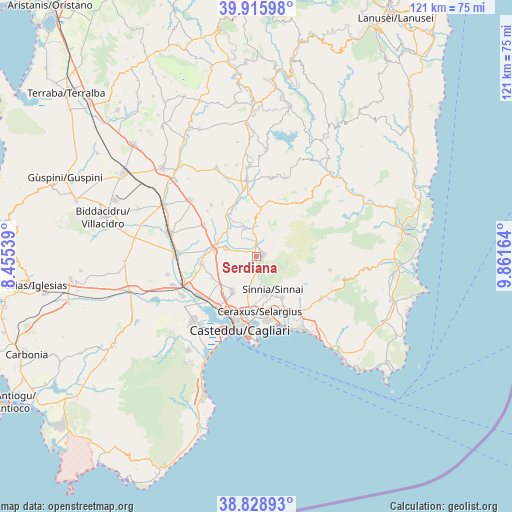
Serdiana GPS coordinates[2]
39° 22' 28.452" North, 9° 9' 30.636" East
| Map corner | latitude | longitude |
|---|---|---|
| Upper-left | 39.91598°, | 8.45539° |
| Center: | 39.37457°, | 9.15851° |
| Lower-right: | 38.82893°, | 9.86164° |
| Map W x H: | 120.9×120.9 km | = 75.1×75.1mi |
| max Lat: | 47.04031° ⇑90.9% North |
| Serdiana: | 39.37457° |
| min Lat: | ⇓9.1% South 35.50142° |
| min Long | Serdiana | max Long |
| 6.69888° | 9.15851° | 18.48682° |
| W 21.3%⇐ | ⇒78.7% E |
Elevation
Elevation of Serdiana is 171 m = 561 ft, and this is 135.7 m = 445 ft below average elevation for this country.
| Max E: |
2085 m = 6841 ft | 59% |
| Avg. | 306.7 m = 1006 ft | |
| Serdiana | 171 m = 561 ft | |
Min E: |
-4 m = -13 ft | 41% |
See also: Italy elevation on elevation.city.
Geographical zone
Serdiana is located in North temperate zone (between Tropic of Cancer and the Arctic Circle). Distance of this Northern Tropic circle is 1772.1 km =1101.1 mi to South.| Distance of | km | miles | from Serdiana |
|---|---|---|---|
| North Pole | 5629 | 3497.7 | to North |
| Arctic Circle | 3023.1 | 1878.5 | to North |
| Tropic Cancer | 1772.1 | 1101.1 | to South |
| Equator | 4378 | 2720.4 | to South |


Nearby cities:
15 places around Serdiana: (largest is in red/bold)
• Barrali
12.2 km =7.6 mi,  336°
336°
• Cortexandra
12 km =7.5 mi,  219°
219°
• Dolianova
1.6 km =1 mi,  76°
76°
• Donorì
6.9 km =4.3 mi, 336°
• Maracalagonis
11.6 km =7.2 mi,  148°
148°
• Monastir
9.9 km =6.2 mi,  275°
275°
• Monserrato
13.2 km =8.2 mi,  185°
185°
• San Sperate
13.1 km =8.1 mi,  261°
261°
• Sant'Andrea Frius
11.7 km =7.3 mi,  4°
4°
• Selargius
13 km =8.1 mi,  178°
178°
• Sestu
10.2 km =6.3 mi,  213°
213°
• Settimo San Pietro
9.6 km =6 mi,  165°
165°
• Sinnai
8.8 km =5.5 mi, 154°
• Soleminis
3.6 km =2.2 mi, 146°
• Ussana
7.5 km =4.7 mi,  286°
286°
Sources, notices
• [Note1] Compared only with cities in Italy existing in our database
• [Src1] Map data: © OpenStreetMap contributors (CC-BY-SA)
• [Src2] Other city data from geonames.org with taken over terms of usage.
• [Src3] Geographical zone / Annual Mean Temperature by Robert A. Rohde @ Wikipedia
