Donorì geodata
Donorì (Sardinia) is a seat of a third-order administrative division; located in Italy in Europe/Rome (GMT+2) time zone. With population of 1,736 people, there are 4595 cities with bigger population in this country. Compared to other cities in Italy, 90.7% of cities are located further ↑North; 79.2% of cities are located further →East and 61.3% of cities have higher elevation than Donorì. Note1


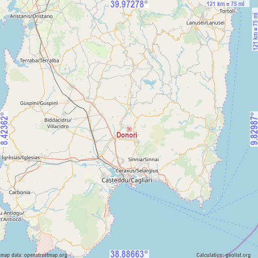
Donorì GPS coordinates[2]
39° 25' 54.552" North, 9° 7' 36.264" East
| Map corner | latitude | longitude |
|---|---|---|
| Upper-left | 39.97278°, | 8.42362° |
| Center: | 39.43182°, | 9.12674° |
| Lower-right: | 38.88663°, | 9.82987° |
| Map W x H: | 120.8×120.8 km | = 75.1×75.1mi |
| max Lat: | 47.04031° ⇑90.7% North |
| Donorì: | 39.43182° |
| min Lat: | ⇓9.3% South 35.50142° |
| min Long | Donorì | max Long |
| 6.69888° | 9.12674° | 18.48682° |
| W 20.8%⇐ | ⇒79.2% E |
Elevation
Elevation of Donorì is 153 m = 502 ft, and this is 153.7 m = 504 ft below average elevation for this country.
| Max E: |
2085 m = 6841 ft | 61.3% |
| Avg. | 306.7 m = 1006 ft | |
| Donorì | 153 m = 502 ft | |
Min E: |
-4 m = -13 ft | 38.7% |
See also: Italy elevation on elevation.city.
Geographical zone
Donorì is located in North temperate zone (between Tropic of Cancer and the Arctic Circle). Distance of this Northern Tropic circle is 1778.5 km =1105.1 mi to South.| Distance of | km | miles | from Donorì |
|---|---|---|---|
| North Pole | 5622.7 | 3493.8 | to North |
| Arctic Circle | 3016.8 | 1874.6 | to North |
| Tropic Cancer | 1778.5 | 1105.1 | to South |
| Equator | 4384.4 | 2724.3 | to South |


Nearby cities:
15 places around Donorì: (largest is in red/bold)
• Barrali
5.3 km =3.3 mi,  336°
336°
• Dolianova
7.4 km =4.6 mi,  144°
144°
• Monastir
8.9 km =5.5 mi,  232°
232°
• Nuraminis
9.8 km =6.1 mi,  277°
277°
• Ortacesus
12.4 km =7.7 mi, 344°
• Pimentel
8.1 km =5 mi,  319°
319°
• Samatzai
9.7 km =6 mi,  305°
305°
• San Basilio
13.3 km =8.3 mi,  27°
27°
• San Sperate
13.1 km =8.1 mi, 230°
• Sant'Andrea Frius
6.4 km =4 mi,  35°
35°
• Senorbì
11.3 km =7 mi,  2°
2°
• Serdiana
6.9 km =4.3 mi,  156°
156°
• Soleminis
10.5 km =6.5 mi,  153°
153°
• Suelli
14.5 km =9 mi, 1°
• Ussana
6.1 km =3.8 mi, 226°
Sources, notices
• [Note1] Compared only with cities in Italy existing in our database
• [Src1] Map data: © OpenStreetMap contributors (CC-BY-SA)
• [Src2] Other city data from geonames.org with taken over terms of usage.
• [Src3] Geographical zone / Annual Mean Temperature by Robert A. Rohde @ Wikipedia
