Ussana geodata
Ussana (Sardinia) is a seat of a third-order administrative division; located in Italy in Europe/Rome (GMT+2) time zone. With population of 4,216 people, there are 2276 cities with bigger population in this country. Compared to other cities in Italy, 90.8% of cities are located further ↑North; 80.2% of cities are located further →East and 69.9% of cities have higher elevation than Ussana. Note1


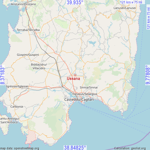
Ussana GPS coordinates[2]
39° 23' 37.464" North, 9° 4' 29.856" East
| Map corner | latitude | longitude |
|---|---|---|
| Upper-left | 39.935°, | 8.37183° |
| Center: | 39.39374°, | 9.07496° |
| Lower-right: | 38.84825°, | 9.77808° |
| Map W x H: | 120.8×120.8 km | = 75.1×75.1mi |
| max Lat: | 47.04031° ⇑90.8% North |
| Ussana: | 39.39374° |
| min Lat: | ⇓9.2% South 35.50142° |
| min Long | Ussana | max Long |
| 6.69888° | 9.07496° | 18.48682° |
| W 19.8%⇐ | ⇒80.2% E |
Elevation
Elevation of Ussana is 98 m = 322 ft, and this is 208.7 m = 685 ft below average elevation for this country.
| Max E: |
2085 m = 6841 ft | 69.9% |
| Avg. | 306.7 m = 1006 ft | |
| Ussana | 98 m = 322 ft | |
Min E: |
-4 m = -13 ft | 30.1% |
See also: Italy elevation on elevation.city.
Geographical zone
Ussana is located in North temperate zone (between Tropic of Cancer and the Arctic Circle). Distance of this Northern Tropic circle is 1774.3 km =1102.5 mi to South.| Distance of | km | miles | from Ussana |
|---|---|---|---|
| North Pole | 5626.9 | 3496.4 | to North |
| Arctic Circle | 3021 | 1877.2 | to North |
| Tropic Cancer | 1774.3 | 1102.5 | to South |
| Equator | 4380.2 | 2721.7 | to South |


Nearby cities:
15 places around Ussana: (largest is in red/bold)
• Barrali
9.4 km =5.8 mi,  14°
14°
• Cortexandra
11.4 km =7.1 mi,  181°
181°
• Decimomannu
13 km =8.1 mi,  224°
224°
• Dolianova
8.9 km =5.5 mi,  101°
101°
• Donorì
6.1 km =3.8 mi,  46°
46°
• Monastir
2.9 km =1.8 mi,  246°
246°
• Nuraminis
7.5 km =4.7 mi,  316°
316°
• Pimentel
10.4 km =6.5 mi,  355°
355°
• Samatzai
10.5 km =6.5 mi,  340°
340°
• San Sperate
7 km =4.3 mi,  235°
235°
• Sant'Andrea Frius
12.5 km =7.8 mi,  40°
40°
• Serdiana
7.5 km =4.7 mi,  106°
106°
• Sestu
10.7 km =6.6 mi,  171°
171°
• Soleminis
10.5 km =6.5 mi,  119°
119°
• Villasor
11.4 km =7.1 mi,  263°
263°
Sources, notices
• [Note1] Compared only with cities in Italy existing in our database
• [Src1] Map data: © OpenStreetMap contributors (CC-BY-SA)
• [Src2] Other city data from geonames.org with taken over terms of usage.
• [Src3] Geographical zone / Annual Mean Temperature by Robert A. Rohde @ Wikipedia
