Scordia geodata
Scordia (Sicily) is a seat of a third-order administrative division; located in Italy in Europe/Rome (GMT+2) time zone. With population of 16,645 people, there are 539 cities with bigger population in this country. Compared to other cities in Italy, 99.3% of cities are located further ↑North; 85.9% of cities are located further ←West and 60.4% of cities have higher elevation than Scordia. Note1


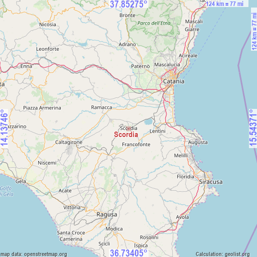
Scordia GPS coordinates[2]
37° 17' 43.728" North, 14° 50' 26.088" East
| Map corner | latitude | longitude |
|---|---|---|
| Upper-left | 37.85275°, | 14.13746° |
| Center: | 37.29548°, | 14.84058° |
| Lower-right: | 36.73405°, | 15.54371° |
| Map W x H: | 124.4×124.4 km | = 77.3×77.3mi |
| max Lat: | 47.04031° ⇑99.3% North |
| Scordia: | 37.29548° |
| min Lat: | ⇓0.7% South 35.50142° |
| min Long | Scordia | max Long |
| 6.69888° | 14.84058° | 18.48682° |
| W 85.9%⇐ | ⇒14.1% E |
Elevation
Elevation of Scordia is 160 m = 525 ft, and this is 146.7 m = 481 ft below average elevation for this country.
| Max E: |
2085 m = 6841 ft | 60.4% |
| Avg. | 306.7 m = 1006 ft | |
| Scordia | 160 m = 525 ft | |
Min E: |
-4 m = -13 ft | 39.6% |
See also: Italy elevation on elevation.city.
Geographical zone
Scordia is located in North temperate zone (between Tropic of Cancer and the Arctic Circle). Distance of this Northern Tropic circle is 1540.9 km =957.5 mi to South.| Distance of | km | miles | from Scordia |
|---|---|---|---|
| North Pole | 5860.2 | 3641.4 | to North |
| Arctic Circle | 3254.3 | 2022.1 | to North |
| Tropic Cancer | 1540.9 | 957.5 | to South |
| Equator | 4146.9 | 2576.8 | to South |


Nearby cities:
15 places around Scordia: (largest is in red/bold)
• Buccheri
19 km =11.8 mi,  176°
176°
• Carlentini
15.1 km =9.4 mi,  96°
96°
• Carlentini Nord
14.9 km =9.3 mi,  90°
90°
• Ferla
21.4 km =13.3 mi,  155°
155°
• Francofonte
8.4 km =5.2 mi, 158°
• Grammichele
20.5 km =12.7 mi,  243°
243°
• Lentini
13.9 km =8.6 mi, 94°
• Licodia Eubea
19.5 km =12.1 mi,  217°
217°
• Militello in Val di Catania
4.7 km =2.9 mi, 242°
• Mineo
13.4 km =8.3 mi,  255°
255°
• Palagonia
9.3 km =5.8 mi,  294°
294°
• Pedagaggi
14.3 km =8.9 mi,  143°
143°
• Ramacca
16.5 km =10.3 mi,  307°
307°
• Sortino
22.6 km =14 mi,  132°
132°
• Vizzini
16.6 km =10.3 mi,  206°
206°
Sources, notices
• [Note1] Compared only with cities in Italy existing in our database
• [Src1] Map data: © OpenStreetMap contributors (CC-BY-SA)
• [Src2] Other city data from geonames.org with taken over terms of usage.
• [Src3] Geographical zone / Annual Mean Temperature by Robert A. Rohde @ Wikipedia
