Lentini geodata
Lentini (Sicily) is a seat of a third-order administrative division; located in Italy in Europe/Rome (GMT+2) time zone. With population of 24,102 people, there are 339 cities with bigger population in this country. Compared to other cities in Italy, 99.3% of cities are located further ↑North; 87.1% of cities are located further ←West and 77.7% of cities have higher elevation than Lentini. Note1


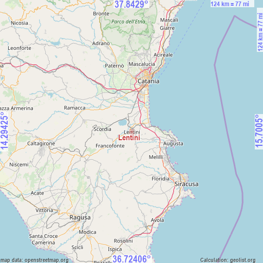
Lentini GPS coordinates[2]
37° 17' 8.016" North, 14° 59' 50.532" East
| Map corner | latitude | longitude |
|---|---|---|
| Upper-left | 37.8429°, | 14.29425° |
| Center: | 37.28556°, | 14.99737° |
| Lower-right: | 36.72406°, | 15.7005° |
| Map W x H: | 124.4×124.4 km | = 77.3×77.3mi |
| max Lat: | 47.04031° ⇑99.3% North |
| Lentini: | 37.28556° |
| min Lat: | ⇓0.7% South 35.50142° |
| min Long | Lentini | max Long |
| 6.69888° | 14.99737° | 18.48682° |
| W 87.1%⇐ | ⇒12.9% E |
Elevation
Elevation of Lentini is 61 m = 200 ft, and this is 245.7 m = 806 ft below average elevation for this country.
| Max E: |
2085 m = 6841 ft | 77.7% |
| Avg. | 306.7 m = 1006 ft | |
| Lentini | 61 m = 200 ft | |
Min E: |
-4 m = -13 ft | 22.3% |
See also: Italy elevation on elevation.city.
Geographical zone
Lentini is located in North temperate zone (between Tropic of Cancer and the Arctic Circle). Distance of this Northern Tropic circle is 1539.8 km =956.8 mi to South.| Distance of | km | miles | from Lentini |
|---|---|---|---|
| North Pole | 5861.3 | 3642 | to North |
| Arctic Circle | 3255.4 | 2022.8 | to North |
| Tropic Cancer | 1539.8 | 956.8 | to South |
| Equator | 4145.8 | 2576.1 | to South |


Nearby cities:
15 places around Lentini: (largest is in red/bold)
• Augusta
20.4 km =12.7 mi,  104°
104°
• Brucoli
16.9 km =10.5 mi,  91°
91°
• Carlentini
1.3 km =0.8 mi,  115°
115°
• Carlentini Nord
1.3 km =0.8 mi,  49°
49°
• Cassaro
20.5 km =12.7 mi,  192°
192°
• Ferla
19.1 km =11.9 mi,  195°
195°
• Francofonte
12.8 km =8 mi,  238°
238°
• Melilli
16.8 km =10.4 mi,  135°
135°
• Militello in Val di Catania
18.1 km =11.2 mi,  266°
266°
• Pedagaggi
11.7 km =7.3 mi,  207°
207°
• Priolo Gargallo
21.9 km =13.6 mi,  131°
131°
• Scordia
13.9 km =8.6 mi, 274°
• Sortino
14.4 km =8.9 mi,  168°
168°
• Vaccarizzo-Delfino
12.2 km =7.6 mi,  37°
37°
• Villasmundo
9.1 km =5.7 mi,  114°
114°
Sources, notices
• [Note1] Compared only with cities in Italy existing in our database
• [Src1] Map data: © OpenStreetMap contributors (CC-BY-SA)
• [Src2] Other city data from geonames.org with taken over terms of usage.
• [Src3] Geographical zone / Annual Mean Temperature by Robert A. Rohde @ Wikipedia
