Grammichele geodata
Grammichele (Sicily) is a seat of a third-order administrative division; located in Italy in Europe/Rome (GMT+2) time zone. With population of 12,844 people, there are 715 cities with bigger population in this country. Compared to other cities in Italy, 99.5% of cities are located further ↑North; 83.9% of cities are located further ←West and 79.7% of cities have lower elevation than Grammichele. Note1


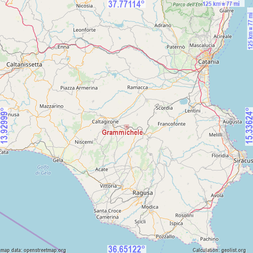
Grammichele GPS coordinates[2]
37° 12' 47.736" North, 14° 37' 59.196" East
| Map corner | latitude | longitude |
|---|---|---|
| Upper-left | 37.77114°, | 13.92999° |
| Center: | 37.21326°, | 14.63311° |
| Lower-right: | 36.65122°, | 15.33624° |
| Map W x H: | 124.5×124.5 km | = 77.4×77.4mi |
| max Lat: | 47.04031° ⇑99.5% North |
| Grammichele: | 37.21326° |
| min Lat: | ⇓0.5% South 35.50142° |
| min Long | Grammichele | max Long |
| 6.69888° | 14.63311° | 18.48682° |
| W 83.9%⇐ | ⇒16.1% E |
Elevation
Elevation of Grammichele is 521 m = 1709 ft, and this is 214.3 m = 703 ft above average elevation for this country.
| Max E: |
2085 m = 6841 ft | 20.3% |
| Grammichele | 521 m 1709 ft | |
| Avg. | 306.7 m = 1006 ft | |
Min E: |
-4 m = -13 ft | 79.7% |
See also: Italy elevation on elevation.city.
Geographical zone
Grammichele is located in North temperate zone (between Tropic of Cancer and the Arctic Circle). Distance of this Northern Tropic circle is 1531.8 km =951.8 mi to South.| Distance of | km | miles | from Grammichele |
|---|---|---|---|
| North Pole | 5869.3 | 3647 | to North |
| Arctic Circle | 3263.4 | 2027.8 | to North |
| Tropic Cancer | 1531.8 | 951.8 | to South |
| Equator | 4137.7 | 2571 | to South |


Nearby cities:
15 places around Grammichele: (largest is in red/bold)
• Caltagirone
10.8 km =6.7 mi,  284°
284°
• Chiaramonte Gulfi
21.2 km =13.2 mi,  163°
163°
• Licodia Eubea
9 km =5.6 mi,  134°
134°
• Mazzarrone
15.3 km =9.5 mi,  204°
204°
• Militello in Val di Catania
15.8 km =9.8 mi,  63°
63°
• Mineo
7.9 km =4.9 mi,  43°
43°
• Mirabella Imbaccari
20.8 km =12.9 mi,  307°
307°
• Monterosso Almo
18.1 km =11.2 mi,  139°
139°
• Palagonia
16.3 km =10.1 mi, 37°
• Ramacca
19.9 km =12.4 mi,  15°
15°
• Roccazzo
17.9 km =11.1 mi,  181°
181°
• San Michele di Ganzaria
19.8 km =12.3 mi,  292°
292°
• Scordia
20.5 km =12.7 mi, 63°
• Villaggio Gulfi
20 km =12.4 mi,  167°
167°
• Vizzini
12.4 km =7.7 mi,  117°
117°
Sources, notices
• [Note1] Compared only with cities in Italy existing in our database
• [Src1] Map data: © OpenStreetMap contributors (CC-BY-SA)
• [Src2] Other city data from geonames.org with taken over terms of usage.
• [Src3] Geographical zone / Annual Mean Temperature by Robert A. Rohde @ Wikipedia
