Roccamena geodata
Roccamena (Sicily) is a seat of a third-order administrative division; located in Italy in Europe/Rome (GMT+2) time zone. With population of 1,544 people, there are 5024 cities with bigger population in this country. Compared to other cities in Italy, 97.6% of cities are located further ↑North; 70% of cities are located further ←West and 76.5% of cities have lower elevation than Roccamena. Note1


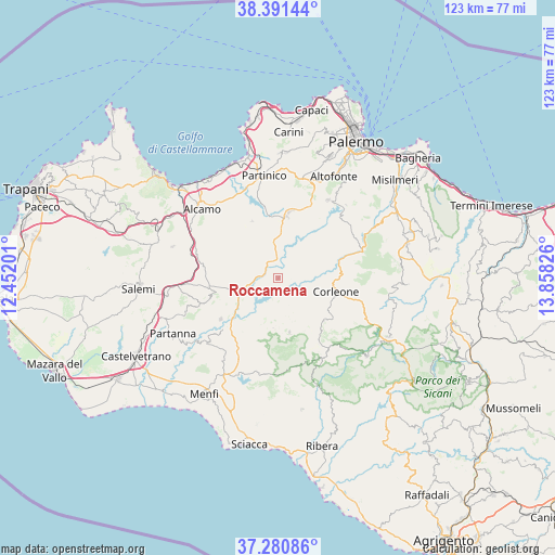
Roccamena GPS coordinates[2]
37° 50' 17.664" North, 13° 9' 18.468" East
| Map corner | latitude | longitude |
|---|---|---|
| Upper-left | 38.39144°, | 12.45201° |
| Center: | 37.83824°, | 13.15513° |
| Lower-right: | 37.28086°, | 13.85826° |
| Map W x H: | 123.5×123.5 km | = 76.7×76.7mi |
| max Lat: | 47.04031° ⇑97.6% North |
| Roccamena: | 37.83824° |
| min Lat: | ⇓2.4% South 35.50142° |
| min Long | Roccamena | max Long |
| 6.69888° | 13.15513° | 18.48682° |
| W 70%⇐ | ⇒30% E |
Elevation
Elevation of Roccamena is 473 m = 1552 ft, and this is 166.3 m = 546 ft above average elevation for this country.
| Max E: |
2085 m = 6841 ft | 23.5% |
| Roccamena | 473 m 1552 ft | |
| Avg. | 306.7 m = 1006 ft | |
Min E: |
-4 m = -13 ft | 76.5% |
See also: Italy elevation on elevation.city.
Geographical zone
Roccamena is located in North temperate zone (between Tropic of Cancer and the Arctic Circle). Distance of this Northern Tropic circle is 1601.3 km =995 mi to South.| Distance of | km | miles | from Roccamena |
|---|---|---|---|
| North Pole | 5799.8 | 3603.8 | to North |
| Arctic Circle | 3194 | 1984.7 | to North |
| Tropic Cancer | 1601.3 | 995 | to South |
| Equator | 4207.2 | 2614.2 | to South |


Nearby cities:
15 places around Roccamena: (largest is in red/bold)
• Bisacquino
17.6 km =10.9 mi,  148°
148°
• Campofiorito
13.7 km =8.5 mi,  133°
133°
• Camporeale
7.1 km =4.4 mi,  318°
318°
• Chiusa Sclafani
20.6 km =12.8 mi, 150°
• Contessa Entellina
12.3 km =7.6 mi,  167°
167°
• Corleone
13.2 km =8.2 mi,  102°
102°
• Giuliana
19.8 km =12.3 mi,  158°
158°
• Grisì
14 km =8.7 mi,  335°
335°
• Nuovo Centro Urbano Poggioreale
13.3 km =8.3 mi,  231°
231°
• Piana degli Albanesi
20.7 km =12.9 mi,  33°
33°
• Salaparuta
15.6 km =9.7 mi, 234°
• Sambuca di Sicilia
20.9 km =13 mi,  189°
189°
• San Cipirello
13.8 km =8.6 mi,  8°
8°
• San Giuseppe Jato
15.3 km =9.5 mi, 11°
• Santa Margherita di Belice
20.3 km =12.6 mi,  217°
217°
Sources, notices
• [Note1] Compared only with cities in Italy existing in our database
• [Src1] Map data: © OpenStreetMap contributors (CC-BY-SA)
• [Src2] Other city data from geonames.org with taken over terms of usage.
• [Src3] Geographical zone / Annual Mean Temperature by Robert A. Rohde @ Wikipedia
