Rodì geodata
Rodì (Sicily) is a seat of a third-order administrative division; located in Italy in Europe/Rome (GMT+2) time zone. With population of 1,436 people, there are 5274 cities with bigger population in this country. Compared to other cities in Italy, 95.6% of cities are located further ↑North; 88.6% of cities are located further ←West and 59.4% of cities have higher elevation than Rodì. Note1


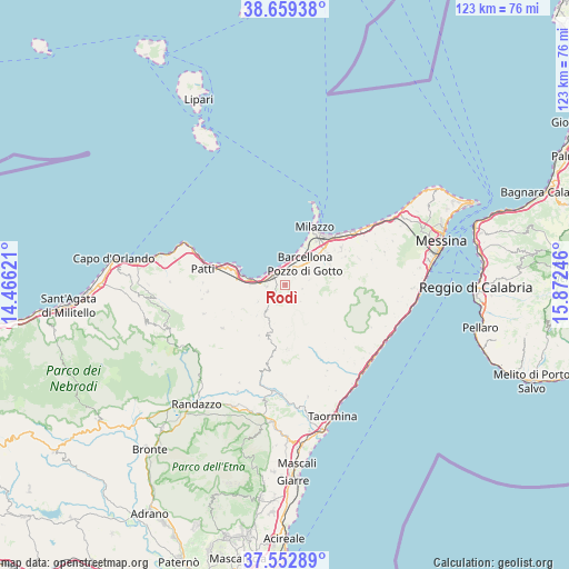
Rodì GPS coordinates[2]
38° 6' 29.628" North, 15° 10' 9.588" East
| Map corner | latitude | longitude |
|---|---|---|
| Upper-left | 38.65938°, | 14.46621° |
| Center: | 38.10823°, | 15.16933° |
| Lower-right: | 37.55289°, | 15.87246° |
| Map W x H: | 123×123 km | = 76.4×76.4mi |
| max Lat: | 47.04031° ⇑95.6% North |
| Rodì: | 38.10823° |
| min Lat: | ⇓4.4% South 35.50142° |
| min Long | Rodì | max Long |
| 6.69888° | 15.16933° | 18.48682° |
| W 88.6%⇐ | ⇒11.4% E |
Elevation
Elevation of Rodì is 168 m = 551 ft, and this is 138.7 m = 455 ft below average elevation for this country.
| Max E: |
2085 m = 6841 ft | 59.4% |
| Avg. | 306.7 m = 1006 ft | |
| Rodì | 168 m = 551 ft | |
Min E: |
-4 m = -13 ft | 40.6% |
See also: Italy elevation on elevation.city.
Geographical zone
Rodì is located in North temperate zone (between Tropic of Cancer and the Arctic Circle). Distance of this Northern Tropic circle is 1631.3 km =1013.6 mi to South.| Distance of | km | miles | from Rodì |
|---|---|---|---|
| North Pole | 5769.8 | 3585.2 | to North |
| Arctic Circle | 3163.9 | 1966 | to North |
| Tropic Cancer | 1631.3 | 1013.6 | to South |
| Equator | 4237.2 | 2632.9 | to South |


Nearby cities:
15 places around Rodì: (largest is in red/bold)
• Acquaficara
4 km =2.5 mi,  54°
54°
• Bafia
4.9 km =3 mi,  140°
140°
• Barcellona Pozzo di Gotto
5.9 km =3.7 mi,  42°
42°
• Castroreale
3.7 km =2.3 mi,  106°
106°
• Falcone
7.9 km =4.9 mi,  277°
277°
• Furnari
4 km =2.5 mi,  263°
263°
• La Gala
5.5 km =3.4 mi,  78°
78°
• Mazzarrà Sant'Andrea
3.6 km =2.2 mi,  235°
235°
• Merì
9.5 km =5.9 mi, 47°
• Protonotaro
2.5 km =1.6 mi,  55°
55°
• San Paolo-Cannistrà
6.3 km =3.9 mi, 63°
• Terme
3.3 km =2.1 mi,  340°
340°
• Tonnarella
5.2 km =3.2 mi,  291°
291°
• Tripi
9.3 km =5.8 mi,  222°
222°
• Vigliatore 2
3.7 km =2.3 mi, 294°
Sources, notices
• [Note1] Compared only with cities in Italy existing in our database
• [Src1] Map data: © OpenStreetMap contributors (CC-BY-SA)
• [Src2] Other city data from geonames.org with taken over terms of usage.
• [Src3] Geographical zone / Annual Mean Temperature by Robert A. Rohde @ Wikipedia
