Realmonte geodata
Realmonte (Sicily) is a seat of a third-order administrative division; located in Italy in Europe/Rome (GMT+2) time zone. With population of 3,443 people, there are 2720 cities with bigger population in this country. Compared to other cities in Italy, 99.3% of cities are located further ↑North; 73.2% of cities are located further ←West and 61.8% of cities have higher elevation than Realmonte. Note1


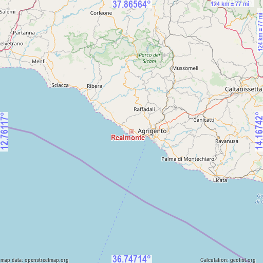
Realmonte GPS coordinates[2]
37° 18' 30.492" North, 13° 27' 51.444" East
| Map corner | latitude | longitude |
|---|---|---|
| Upper-left | 37.86564°, | 12.76117° |
| Center: | 37.30847°, | 13.46429° |
| Lower-right: | 36.74714°, | 14.16742° |
| Map W x H: | 124.4×124.4 km | = 77.3×77.3mi |
| max Lat: | 47.04031° ⇑99.3% North |
| Realmonte: | 37.30847° |
| min Lat: | ⇓0.7% South 35.50142° |
| min Long | Realmonte | max Long |
| 6.69888° | 13.46429° | 18.48682° |
| W 73.2%⇐ | ⇒26.8% E |
Elevation
Elevation of Realmonte is 150 m = 492 ft, and this is 156.7 m = 514 ft below average elevation for this country.
| Max E: |
2085 m = 6841 ft | 61.8% |
| Avg. | 306.7 m = 1006 ft | |
| Realmonte | 150 m = 492 ft | |
Min E: |
-4 m = -13 ft | 38.2% |
See also: Italy elevation on elevation.city.
Geographical zone
Realmonte is located in North temperate zone (between Tropic of Cancer and the Arctic Circle). Distance of this Northern Tropic circle is 1542.4 km =958.4 mi to South.| Distance of | km | miles | from Realmonte |
|---|---|---|---|
| North Pole | 5858.7 | 3640.4 | to North |
| Arctic Circle | 3252.9 | 2021.3 | to North |
| Tropic Cancer | 1542.4 | 958.4 | to South |
| Equator | 4148.3 | 2577.6 | to South |


Nearby cities:
15 places around Realmonte: (largest is in red/bold)
• Agrigento
9.9 km =6.2 mi,  88°
88°
• Aragona
17 km =10.6 mi,  53°
53°
• Cattolica Eraclea
16 km =9.9 mi,  336°
336°
• Comitini
19.4 km =12.1 mi,  55°
55°
• Favara
17.5 km =10.9 mi, 86°
• Giardina Gallotti
7 km =4.3 mi, 47°
• Joppolo Giancaxio
11.9 km =7.4 mi,  42°
42°
• Montallegro
13.5 km =8.4 mi,  312°
312°
• Porto Empedocle
5.8 km =3.6 mi,  111°
111°
• Raffadali
12 km =7.5 mi,  29°
29°
• San Leone Mosè
11.7 km =7.3 mi, 114°
• Sant'Angelo Muxaro
20.4 km =12.7 mi,  20°
20°
• Santa Elisabetta
15.8 km =9.8 mi, 30°
• Siculiana
4.6 km =2.9 mi, 310°
• Villaseta
8.5 km =5.3 mi,  97°
97°
Sources, notices
• [Note1] Compared only with cities in Italy existing in our database
• [Src1] Map data: © OpenStreetMap contributors (CC-BY-SA)
• [Src2] Other city data from geonames.org with taken over terms of usage.
• [Src3] Geographical zone / Annual Mean Temperature by Robert A. Rohde @ Wikipedia
