Randazzo geodata
Randazzo (Sicily) is a seat of a third-order administrative division; located in Italy in Europe/Rome (GMT+2) time zone. With population of 9,949 people, there are 955 cities with bigger population in this country. Compared to other cities in Italy, 97.5% of cities are located further ↑North; 86.8% of cities are located further ←West and 91.4% of cities have lower elevation than Randazzo. Note1


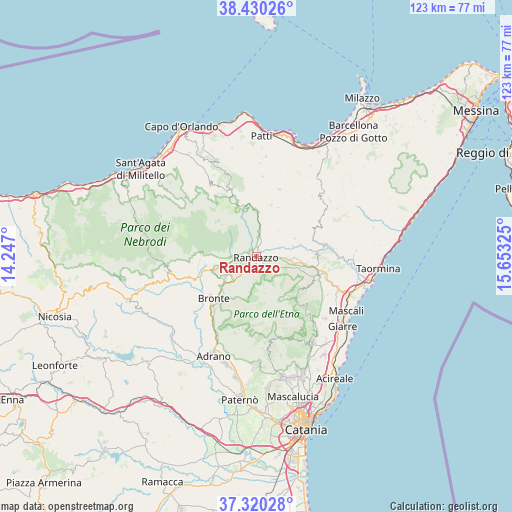
Randazzo GPS coordinates[2]
37° 52' 38.496" North, 14° 57' 0.432" East
| Map corner | latitude | longitude |
|---|---|---|
| Upper-left | 38.43026°, | 14.247° |
| Center: | 37.87736°, | 14.95012° |
| Lower-right: | 37.32028°, | 15.65325° |
| Map W x H: | 123.4×123.4 km | = 76.7×76.7mi |
| max Lat: | 47.04031° ⇑97.5% North |
| Randazzo: | 37.87736° |
| min Lat: | ⇓2.5% South 35.50142° |
| min Long | Randazzo | max Long |
| 6.69888° | 14.95012° | 18.48682° |
| W 86.8%⇐ | ⇒13.2% E |
Elevation
Elevation of Randazzo is 754 m = 2474 ft, and this is 447.3 m = 1468 ft above average elevation for this country.
| Max E: |
2085 m = 6841 ft | 8.6% |
| Randazzo | 754 m 2474 ft | |
| Avg. | 306.7 m = 1006 ft | |
Min E: |
-4 m = -13 ft | 91.4% |
See also: Italy elevation on elevation.city.
Geographical zone
Randazzo is located in North temperate zone (between Tropic of Cancer and the Arctic Circle). Distance of this Northern Tropic circle is 1605.6 km =997.7 mi to South.| Distance of | km | miles | from Randazzo |
|---|---|---|---|
| North Pole | 5795.5 | 3601.2 | to North |
| Arctic Circle | 3189.6 | 1981.9 | to North |
| Tropic Cancer | 1605.6 | 997.7 | to South |
| Equator | 4211.6 | 2617 | to South |


Nearby cities:
15 places around Randazzo: (largest is in red/bold)
• Bronte
14.2 km =8.8 mi,  226°
226°
• Castiglione di Sicilia
15.1 km =9.4 mi,  88°
88°
• Floresta
12.7 km =7.9 mi,  344°
344°
• Fondaco-Margherito
12.7 km =7.9 mi,  263°
263°
• Francavilla di Sicilia
16.7 km =10.4 mi,  80°
80°
• Linguaglossa
16.9 km =10.5 mi,  103°
103°
• Maletto
9.3 km =5.8 mi, 234°
• Malvagna
10.3 km =6.4 mi,  64°
64°
• Maniace
13.4 km =8.3 mi,  272°
272°
• Moio Alcantara
9.2 km =5.7 mi,  73°
73°
• Montalbano Elicona
17.2 km =10.7 mi,  18°
18°
• Petrosino
13.3 km =8.3 mi, 273°
• Roccella Valdemone
8.1 km =5 mi,  40°
40°
• Santa Domenica Vittoria
4.5 km =2.8 mi,  14°
14°
• Solicchiata
10.2 km =6.3 mi, 98°
Sources, notices
• [Note1] Compared only with cities in Italy existing in our database
• [Src1] Map data: © OpenStreetMap contributors (CC-BY-SA)
• [Src2] Other city data from geonames.org with taken over terms of usage.
• [Src3] Geographical zone / Annual Mean Temperature by Robert A. Rohde @ Wikipedia
