Maniace geodata
Maniace (Sicily) is a seat of a third-order administrative division; located in Italy in Europe/Rome (GMT+2) time zone. With population of 3,543 people, there are 2648 cities with bigger population in this country. Compared to other cities in Italy, 97.4% of cities are located further ↑North; 85.5% of cities are located further ←West and 92.6% of cities have lower elevation than Maniace. Note1


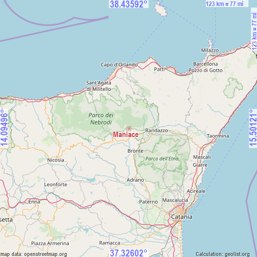
Maniace GPS coordinates[2]
37° 52' 59.016" North, 14° 47' 53.088" East
| Map corner | latitude | longitude |
|---|---|---|
| Upper-left | 38.43592°, | 14.09496° |
| Center: | 37.88306°, | 14.79808° |
| Lower-right: | 37.32602°, | 15.50121° |
| Map W x H: | 123.4×123.4 km | = 76.7×76.7mi |
| max Lat: | 47.04031° ⇑97.4% North |
| Maniace: | 37.88306° |
| min Lat: | ⇓2.6% South 35.50142° |
| min Long | Maniace | max Long |
| 6.69888° | 14.79808° | 18.48682° |
| W 85.5%⇐ | ⇒14.5% E |
Elevation
Elevation of Maniace is 787 m = 2582 ft, and this is 480.3 m = 1576 ft above average elevation for this country.
| Max E: |
2085 m = 6841 ft | 7.4% |
| Maniace | 787 m 2582 ft | |
| Avg. | 306.7 m = 1006 ft | |
Min E: |
-4 m = -13 ft | 92.6% |
See also: Italy elevation on elevation.city.
Geographical zone
Maniace is located in North temperate zone (between Tropic of Cancer and the Arctic Circle). Distance of this Northern Tropic circle is 1606.3 km =998.1 mi to South.| Distance of | km | miles | from Maniace |
|---|---|---|---|
| North Pole | 5794.9 | 3600.8 | to North |
| Arctic Circle | 3189 | 1981.6 | to North |
| Tropic Cancer | 1606.3 | 998.1 | to South |
| Equator | 4212.2 | 2617.3 | to South |


Nearby cities:
15 places around Maniace: (largest is in red/bold)
• Alcara Li Fusi
17.6 km =10.9 mi,  331°
331°
• Bronte
11 km =6.8 mi,  163°
163°
• Cesarò
8.6 km =5.3 mi,  240°
240°
• Floresta
15.3 km =9.5 mi,  40°
40°
• Fondaco-Margherito
2.2 km =1.4 mi, 160°
• Galati Mamertino
16.7 km =10.4 mi,  351°
351°
• Longi
16.4 km =10.2 mi, 346°
• Maletto
8.3 km =5.2 mi,  135°
135°
• Petrosino
0.1 km =0.1 mi, 43°
• Randazzo
13.4 km =8.3 mi,  92°
92°
• Roccella Valdemone
19.4 km =12.1 mi,  73°
73°
• San Basilio
15 km =9.3 mi, 353°
• San Teodoro
9.5 km =5.9 mi,  245°
245°
• Santa Domenica Vittoria
14.9 km =9.3 mi,  75°
75°
• Tortorici
16.4 km =10.2 mi,  7°
7°
Sources, notices
• [Note1] Compared only with cities in Italy existing in our database
• [Src1] Map data: © OpenStreetMap contributors (CC-BY-SA)
• [Src2] Other city data from geonames.org with taken over terms of usage.
• [Src3] Geographical zone / Annual Mean Temperature by Robert A. Rohde @ Wikipedia
