Pula geodata
Pula (Sardinia) is a seat of a third-order administrative division; located in Italy in Europe/Rome (GMT+2) time zone. With population of 4,883 people, there are 2003 cities with bigger population in this country. Compared to other cities in Italy, 92.6% of cities are located further ↑North; 81.2% of cities are located further →East and 92.6% of cities have higher elevation than Pula. Note1


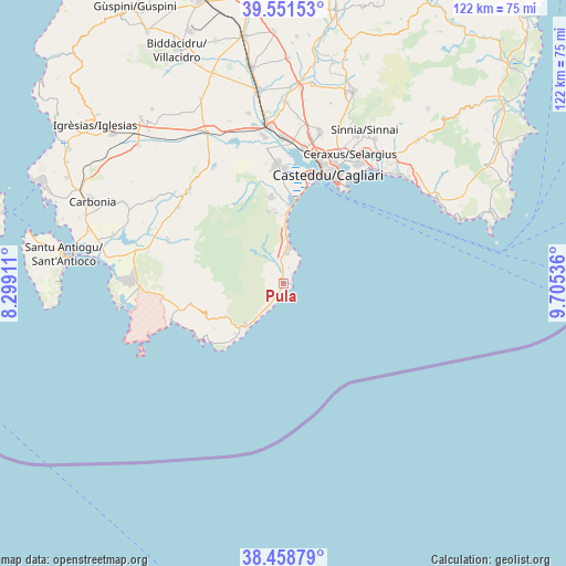
Pula GPS coordinates[2]
39° 0' 26.172" North, 9° 0' 8.028" East
| Map corner | latitude | longitude |
|---|---|---|
| Upper-left | 39.55153°, | 8.29911° |
| Center: | 39.00727°, | 9.00223° |
| Lower-right: | 38.45879°, | 9.70536° |
| Map W x H: | 121.5×121.5 km | = 75.5×75.5mi |
| max Lat: | 47.04031° ⇑92.6% North |
| Pula: | 39.00727° |
| min Lat: | ⇓7.4% South 35.50142° |
| min Long | Pula | max Long |
| 6.69888° | 9.00223° | 18.48682° |
| W 18.8%⇐ | ⇒81.2% E |
Elevation
Elevation of Pula is 13 m = 43 ft, and this is 293.7 m = 964 ft below average elevation for this country.
| Max E: |
2085 m = 6841 ft | 92.6% |
| Avg. | 306.7 m = 1006 ft | |
| Pula | 13 m = 43 ft | |
Min E: |
-4 m = -13 ft | 7.4% |
See also: Italy elevation on elevation.city.
Geographical zone
Pula is located in North temperate zone (between Tropic of Cancer and the Arctic Circle). Distance of this Northern Tropic circle is 1731.3 km =1075.8 mi to South.| Distance of | km | miles | from Pula |
|---|---|---|---|
| North Pole | 5669.9 | 3523.1 | to North |
| Arctic Circle | 3064 | 1903.9 | to North |
| Tropic Cancer | 1731.3 | 1075.8 | to South |
| Equator | 4337.2 | 2695 | to South |


Nearby cities:
15 places around Pula: (largest is in red/bold)
• Cagliari
26.8 km =16.7 mi,  22°
22°
• Capoterra
18.9 km =11.7 mi,  352°
352°
• Coop. Cento
14.6 km =9.1 mi,  357°
357°
• Domus de Maria
13.9 km =8.6 mi,  239°
239°
• Elmas
29.4 km =18.3 mi,  8°
8°
• La Maddalena
15.3 km =9.5 mi,  3°
3°
• Monserrato
30.3 km =18.8 mi, 23°
• Nuxis
28 km =17.4 mi,  305°
305°
• Piscinas
30 km =18.6 mi,  284°
284°
• Poggio dei Pini
15.8 km =9.8 mi, 350°
• Santadi
26.8 km =16.7 mi,  290°
290°
• Sarroch
6.5 km =4 mi, 5°
• Su Planu
29 km =18 mi, 18°
• Teulada
20.4 km =12.7 mi,  257°
257°
• Villa San Pietro
3.2 km =2 mi, 351°
Sources, notices
• [Note1] Compared only with cities in Italy existing in our database
• [Src1] Map data: © OpenStreetMap contributors (CC-BY-SA)
• [Src2] Other city data from geonames.org with taken over terms of usage.
• [Src3] Geographical zone / Annual Mean Temperature by Robert A. Rohde @ Wikipedia
