Polistena geodata
Polistena (Calabria) is a seat of a third-order administrative division; located in Italy in Europe/Rome (GMT+2) time zone. With population of 9,672 people, there are 978 cities with bigger population in this country. Compared to other cities in Italy, 94.4% of cities are located further ↑North; 93.3% of cities are located further ←West and 51.4% of cities have higher elevation than Polistena. Note1
Administrative division(s):
- Level 1: Calabria
- Level 2: Provincia di Reggio Calabria
- Level 3: Polistena


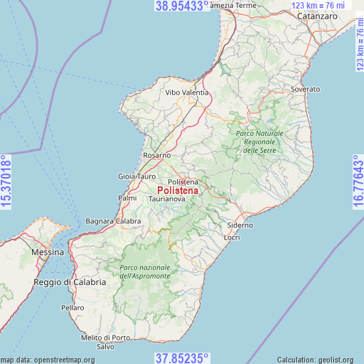
Polistena GPS coordinates[2]
38° 24' 19.584" North, 16° 4' 23.88" East
| Map corner | latitude | longitude |
|---|---|---|
| Upper-left | 38.95433°, | 15.37018° |
| Center: | 38.40544°, | 16.0733° |
| Lower-right: | 37.85235°, | 16.77643° |
| Map W x H: | 122.5×122.5 km | = 76.1×76.1mi |
| max Lat: | 47.04031° ⇑94.4% North |
| Polistena: | 38.40544° |
| min Lat: | ⇓5.6% South 35.50142° |
| min Long | Polistena | max Long |
| 6.69888° | 16.0733° | 18.48682° |
| W 93.3%⇐ | ⇒6.7% E |
Elevation
Elevation of Polistena is 225 m = 738 ft, and this is 81.7 m = 268 ft below average elevation for this country.
| Max E: |
2085 m = 6841 ft | 51.4% |
| Avg. | 306.7 m = 1006 ft | |
| Polistena | 225 m = 738 ft | |
Min E: |
-4 m = -13 ft | 48.6% |
See also: Italy elevation on elevation.city.
Geographical zone
Polistena is located in North temperate zone (between Tropic of Cancer and the Arctic Circle). Distance of this Northern Tropic circle is 1664.4 km =1034.2 mi to South.| Distance of | km | miles | from Polistena |
|---|---|---|---|
| North Pole | 5736.8 | 3564.7 | to North |
| Arctic Circle | 3130.9 | 1945.5 | to North |
| Tropic Cancer | 1664.4 | 1034.2 | to South |
| Equator | 4270.3 | 2653.4 | to South |


Nearby cities:
15 places around Polistena: (largest is in red/bold)
• Amato
5.8 km =3.6 mi,  115°
115°
• Anoia Inferiore
3.5 km =2.2 mi,  8°
8°
• Anoia Superiore
3.6 km =2.2 mi,  35°
35°
• Cinque Frondi
1.5 km =0.9 mi, 38°
• Cittanova
5.7 km =3.5 mi,  175°
175°
• Feroleto della Chiesa
6.7 km =4.2 mi,  357°
357°
• Galatro
6.9 km =4.3 mi,  26°
26°
• Giffone
7.6 km =4.7 mi,  60°
60°
• Laureana di Borrello
9.7 km =6 mi, 5°
• Maropati
4.6 km =2.9 mi, 27°
• Melicucco
3.4 km =2.1 mi,  335°
335°
• San Giorgio Morgeto
2 km =1.2 mi,  139°
139°
• Spina
7.6 km =4.7 mi,  280°
280°
• Taurianova
7.7 km =4.8 mi,  223°
223°
• Tritanti
5.4 km =3.4 mi, 26°
Sources, notices
• [Note1] Compared only with cities in Italy existing in our database
• [Src1] Map data: © OpenStreetMap contributors (CC-BY-SA)
• [Src2] Other city data from geonames.org with taken over terms of usage.
• [Src3] Geographical zone / Annual Mean Temperature by Robert A. Rohde @ Wikipedia
