Tritanti geodata
Tritanti (Calabria) is a populated place; located in Italy in Europe/Rome (GMT+2) time zone. With population of 519 people, there are 9740 cities with bigger population in this country. Compared to other cities in Italy, 94.2% of cities are located further ↑North; 93.6% of cities are located further ←West and 55.1% of cities have lower elevation than Tritanti. Note1
Administrative division(s):
- Level 1: Calabria
- Level 2: Provincia di Reggio Calabria
- Level 3: Maropati


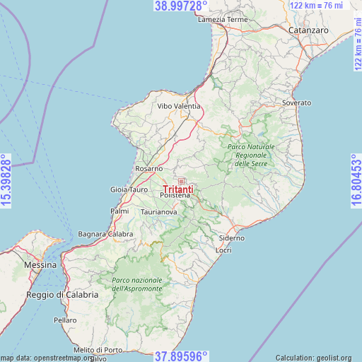
Tritanti GPS coordinates[2]
38° 26' 55.392" North, 16° 6' 5.04" East
| Map corner | latitude | longitude |
|---|---|---|
| Upper-left | 38.99728°, | 15.39828° |
| Center: | 38.44872°, | 16.1014° |
| Lower-right: | 37.89596°, | 16.80453° |
| Map W x H: | 122.5×122.5 km | = 76.1×76.1mi |
| max Lat: | 47.04031° ⇑94.2% North |
| Tritanti: | 38.44872° |
| min Lat: | ⇓5.8% South 35.50142° |
| min Long | Tritanti | max Long |
| 6.69888° | 16.1014° | 18.48682° |
| W 93.6%⇐ | ⇒6.4% E |
Elevation
Elevation of Tritanti is 266 m = 873 ft, and this is 40.7 m = 134 ft below average elevation for this country.
| Max E: |
2085 m = 6841 ft | 44.9% |
| Avg. | 306.7 m = 1006 ft | |
| Tritanti | 266 m = 873 ft | |
Min E: |
-4 m = -13 ft | 55.1% |
See also: Italy elevation on elevation.city.
Geographical zone
Tritanti is located in North temperate zone (between Tropic of Cancer and the Arctic Circle). Distance of this Northern Tropic circle is 1669.2 km =1037.2 mi to South.| Distance of | km | miles | from Tritanti |
|---|---|---|---|
| North Pole | 5732 | 3561.7 | to North |
| Arctic Circle | 3126.1 | 1942.5 | to North |
| Tropic Cancer | 1669.2 | 1037.2 | to South |
| Equator | 4275.1 | 2656.4 | to South |


Nearby cities:
15 places around Tritanti: (largest is in red/bold)
• Amato
7.8 km =4.8 mi,  159°
159°
• Anoia Inferiore
2.4 km =1.5 mi,  233°
233°
• Anoia Superiore
2 km =1.2 mi,  190°
190°
• Candidoni
6.4 km =4 mi,  348°
348°
• Cinque Frondi
3.9 km =2.4 mi,  202°
202°
• Feroleto della Chiesa
3.3 km =2.1 mi,  305°
305°
• Galatro
1.5 km =0.9 mi,  24°
24°
• Giffone
4.3 km =2.7 mi,  103°
103°
• Laureana di Borrello
5.1 km =3.2 mi,  342°
342°
• Maropati
0.8 km =0.5 mi, 203°
• Melicucco
4.2 km =2.6 mi,  245°
245°
• Polistena
5.4 km =3.4 mi,  206°
206°
• San Giorgio Morgeto
6.4 km =4 mi, 190°
• San Pietro di Caridà
8.8 km =5.5 mi, 19°
• Serrata
7.1 km =4.4 mi,  359°
359°
Sources, notices
• [Note1] Compared only with cities in Italy existing in our database
• [Src1] Map data: © OpenStreetMap contributors (CC-BY-SA)
• [Src2] Other city data from geonames.org with taken over terms of usage.
• [Src3] Geographical zone / Annual Mean Temperature by Robert A. Rohde @ Wikipedia
