Palmi geodata
Palmi (Calabria) is a seat of a third-order administrative division; located in Italy in Europe/Rome (GMT+2) time zone. With population of 18,556 people, there are 474 cities with bigger population in this country. Compared to other cities in Italy, 94.5% of cities are located further ↑North; 92% of cities are located further ←West and 54.7% of cities have lower elevation than Palmi. Note1


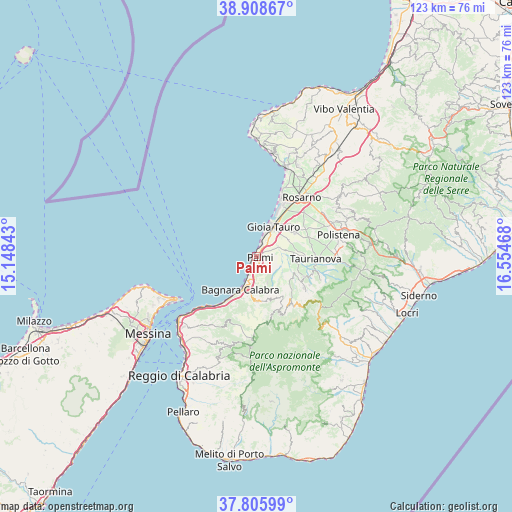
Palmi GPS coordinates[2]
38° 21' 33.948" North, 15° 51' 5.58" East
| Map corner | latitude | longitude |
|---|---|---|
| Upper-left | 38.90867°, | 15.14843° |
| Center: | 38.35943°, | 15.85155° |
| Lower-right: | 37.80599°, | 16.55468° |
| Map W x H: | 122.6×122.6 km | = 76.2×76.2mi |
| max Lat: | 47.04031° ⇑94.5% North |
| Palmi: | 38.35943° |
| min Lat: | ⇓5.5% South 35.50142° |
| min Long | Palmi | max Long |
| 6.69888° | 15.85155° | 18.48682° |
| W 92%⇐ | ⇒8% E |
Elevation
Elevation of Palmi is 264 m = 866 ft, and this is 42.7 m = 140 ft below average elevation for this country.
| Max E: |
2085 m = 6841 ft | 45.3% |
| Avg. | 306.7 m = 1006 ft | |
| Palmi | 264 m = 866 ft | |
Min E: |
-4 m = -13 ft | 54.7% |
See also: Italy elevation on elevation.city.
Geographical zone
Palmi is located in North temperate zone (between Tropic of Cancer and the Arctic Circle). Distance of this Northern Tropic circle is 1659.2 km =1031 mi to South.| Distance of | km | miles | from Palmi |
|---|---|---|---|
| North Pole | 5741.9 | 3567.9 | to North |
| Arctic Circle | 3136 | 1948.6 | to North |
| Tropic Cancer | 1659.2 | 1031 | to South |
| Equator | 4265.2 | 2650.3 | to South |


Nearby cities:
15 places around Palmi: (largest is in red/bold)
• Amato
9.7 km =6 mi,  80°
80°
• Bagnara Calabra
8.9 km =5.5 mi,  206°
206°
• Barritteri
3.3 km =2.1 mi,  183°
183°
• Castellace
9 km =5.6 mi,  121°
121°
• Ceramida-Pellegrina
7.3 km =4.5 mi,  197°
197°
• Cosoleto
11.5 km =7.1 mi,  144°
144°
• Drosi
11.8 km =7.3 mi,  51°
51°
• Gioia Tauro
8.3 km =5.2 mi,  28°
28°
• Melicuccà
6.8 km =4.2 mi,  157°
157°
• Rizziconi
11 km =6.8 mi,  59°
59°
• San Martino
10.9 km =6.8 mi,  88°
88°
• San Procopio
9.3 km =5.8 mi, 158°
• Sant'Eufemia d'Aspromonte
10.7 km =6.6 mi, 177°
• Seminara
3.1 km =1.9 mi,  147°
147°
• Sinopoli
10.9 km =6.8 mi,  168°
168°
Sources, notices
• [Note1] Compared only with cities in Italy existing in our database
• [Src1] Map data: © OpenStreetMap contributors (CC-BY-SA)
• [Src2] Other city data from geonames.org with taken over terms of usage.
• [Src3] Geographical zone / Annual Mean Temperature by Robert A. Rohde @ Wikipedia
