Osini geodata
Osini (Sardinia) is a seat of a third-order administrative division; located in Italy in Europe/Rome (GMT+2) time zone. With population of 781 people, there are 7747 cities with bigger population in this country. Compared to other cities in Italy, 88.9% of cities are located further ↑North; 73.3% of cities are located further →East and 86.6% of cities have lower elevation than Osini. Note1


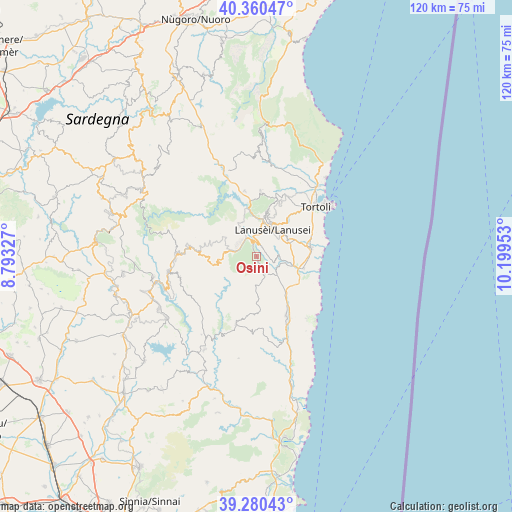
Osini GPS coordinates[2]
39° 49' 21.252" North, 9° 29' 47.04" East
| Map corner | latitude | longitude |
|---|---|---|
| Upper-left | 40.36047°, | 8.79327° |
| Center: | 39.82257°, | 9.4964° |
| Lower-right: | 39.28043°, | 10.19953° |
| Map W x H: | 120.1×120.1 km | = 74.6×74.6mi |
| max Lat: | 47.04031° ⇑88.9% North |
| Osini: | 39.82257° |
| min Lat: | ⇓11.1% South 35.50142° |
| min Long | Osini | max Long |
| 6.69888° | 9.4964° | 18.48682° |
| W 26.7%⇐ | ⇒73.3% E |
Elevation
Elevation of Osini is 644 m = 2113 ft, and this is 337.3 m = 1107 ft above average elevation for this country.
| Max E: |
2085 m = 6841 ft | 13.4% |
| Osini | 644 m 2113 ft | |
| Avg. | 306.7 m = 1006 ft | |
Min E: |
-4 m = -13 ft | 86.6% |
See also: Italy elevation on elevation.city.
Geographical zone
Osini is located in North temperate zone (between Tropic of Cancer and the Arctic Circle). Distance of this Northern Tropic circle is 1821.9 km =1132.1 mi to South.| Distance of | km | miles | from Osini |
|---|---|---|---|
| North Pole | 5579.2 | 3466.8 | to North |
| Arctic Circle | 2973.3 | 1847.5 | to North |
| Tropic Cancer | 1821.9 | 1132.1 | to South |
| Equator | 4427.9 | 2751.4 | to South |


Nearby cities:
15 places around Osini: (largest is in red/bold)
• Arzana
10.9 km =6.8 mi,  14°
14°
• Bari Sardo
12.9 km =8 mi,  80°
80°
• Cardedu
11.5 km =7.1 mi,  104°
104°
• Elini
9.1 km =5.7 mi,  19°
19°
• Gairo Sant'Elena
3.1 km =1.9 mi, 13°
• Ilbono
8.9 km =5.5 mi,  28°
28°
• Jerzu
3.8 km =2.4 mi,  150°
150°
• Lanusei
7.3 km =4.5 mi, 30°
• Loceri
8.4 km =5.2 mi,  62°
62°
• Seui
14.9 km =9.3 mi,  277°
277°
• Tertenia
15.8 km =9.8 mi, 153°
• Ulassai
1.4 km =0.9 mi,  168°
168°
• Ussassai
8.8 km =5.5 mi,  260°
260°
• Villagrande Strisaili
15.2 km =9.4 mi,  4°
4°
• Villanova Strisaili
15.5 km =9.6 mi,  349°
349°
Sources, notices
• [Note1] Compared only with cities in Italy existing in our database
• [Src1] Map data: © OpenStreetMap contributors (CC-BY-SA)
• [Src2] Other city data from geonames.org with taken over terms of usage.
• [Src3] Geographical zone / Annual Mean Temperature by Robert A. Rohde @ Wikipedia
