Tertenia geodata
Tertenia (Sardinia) is a seat of a third-order administrative division; located in Italy in Europe/Rome (GMT+2) time zone. With population of 3,045 people, there are 3000 cities with bigger population in this country. Compared to other cities in Italy, 89.5% of cities are located further ↑North; 72.3% of cities are located further →East and 64.7% of cities have higher elevation than Tertenia. Note1


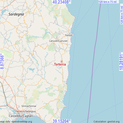
Tertenia GPS coordinates[2]
39° 41' 42.648" North, 9° 34' 43.608" East
| Map corner | latitude | longitude |
|---|---|---|
| Upper-left | 40.23408°, | 8.87566° |
| Center: | 39.69518°, | 9.57878° |
| Lower-right: | 39.15204°, | 10.28191° |
| Map W x H: | 120.3×120.3 km | = 74.8×74.8mi |
| max Lat: | 47.04031° ⇑89.5% North |
| Tertenia: | 39.69518° |
| min Lat: | ⇓10.5% South 35.50142° |
| min Long | Tertenia | max Long |
| 6.69888° | 9.57878° | 18.48682° |
| W 27.7%⇐ | ⇒72.3% E |
Elevation
Elevation of Tertenia is 129 m = 423 ft, and this is 177.7 m = 583 ft below average elevation for this country.
| Max E: |
2085 m = 6841 ft | 64.7% |
| Avg. | 306.7 m = 1006 ft | |
| Tertenia | 129 m = 423 ft | |
Min E: |
-4 m = -13 ft | 35.3% |
See also: Italy elevation on elevation.city.
Geographical zone
Tertenia is located in North temperate zone (between Tropic of Cancer and the Arctic Circle). Distance of this Northern Tropic circle is 1807.8 km =1123.3 mi to South.| Distance of | km | miles | from Tertenia |
|---|---|---|---|
| North Pole | 5593.4 | 3475.6 | to North |
| Arctic Circle | 2987.5 | 1856.3 | to North |
| Tropic Cancer | 1807.8 | 1123.3 | to South |
| Equator | 4413.7 | 2742.5 | to South |


Nearby cities:
15 places around Tertenia: (largest is in red/bold)
• Arzana
25.1 km =15.6 mi,  349°
349°
• Ballao
24.7 km =15.3 mi,  228°
228°
• Bari Sardo
17.2 km =10.7 mi,  19°
19°
• Cardedu
12 km =7.5 mi, 19°
• Elini
23.1 km =14.4 mi, 350°
• Escalaplano
20.8 km =12.9 mi,  248°
248°
• Gairo Sant'Elena
18.3 km =11.4 mi,  339°
339°
• Ilbono
22.1 km =13.7 mi, 352°
• Jerzu
12 km =7.5 mi,  334°
334°
• Lanusei
20.7 km =12.9 mi, 350°
• Loceri
18.1 km =11.2 mi,  1°
1°
• Osini
15.8 km =9.8 mi, 333°
• Perdasdefogu
11.9 km =7.4 mi,  261°
261°
• Ulassai
14.5 km =9 mi, 332°
• Ussassai
20.2 km =12.6 mi,  309°
309°
Sources, notices
• [Note1] Compared only with cities in Italy existing in our database
• [Src1] Map data: © OpenStreetMap contributors (CC-BY-SA)
• [Src2] Other city data from geonames.org with taken over terms of usage.
• [Src3] Geographical zone / Annual Mean Temperature by Robert A. Rohde @ Wikipedia
