Oliveri geodata
Oliveri (Sicily) is a seat of a third-order administrative division; located in Italy in Europe/Rome (GMT+2) time zone. With population of 2,157 people, there are 3924 cities with bigger population in this country. Compared to other cities in Italy, 95.5% of cities are located further ↑North; 87.7% of cities are located further ←West and 95.3% of cities have higher elevation than Oliveri. Note1


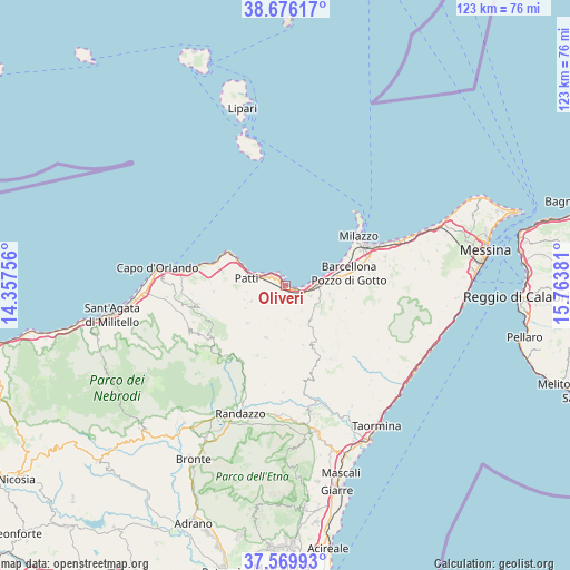
Oliveri GPS coordinates[2]
38° 7' 30.54" North, 15° 3' 38.448" East
| Map corner | latitude | longitude |
|---|---|---|
| Upper-left | 38.67617°, | 14.35756° |
| Center: | 38.12515°, | 15.06068° |
| Lower-right: | 37.56993°, | 15.76381° |
| Map W x H: | 123×123 km | = 76.4×76.4mi |
| max Lat: | 47.04031° ⇑95.5% North |
| Oliveri: | 38.12515° |
| min Lat: | ⇓4.5% South 35.50142° |
| min Long | Oliveri | max Long |
| 6.69888° | 15.06068° | 18.48682° |
| W 87.7%⇐ | ⇒12.3% E |
Elevation
Elevation of Oliveri is 8 m = 26 ft, and this is 298.7 m = 980 ft below average elevation for this country.
| Max E: |
2085 m = 6841 ft | 95.3% |
| Avg. | 306.7 m = 1006 ft | |
| Oliveri | 8 m = 26 ft | |
Min E: |
-4 m = -13 ft | 4.7% |
See also: Italy elevation on elevation.city.
Geographical zone
Oliveri is located in North temperate zone (between Tropic of Cancer and the Arctic Circle). Distance of this Northern Tropic circle is 1633.2 km =1014.8 mi to South.| Distance of | km | miles | from Oliveri |
|---|---|---|---|
| North Pole | 5767.9 | 3584 | to North |
| Arctic Circle | 3162.1 | 1964.8 | to North |
| Tropic Cancer | 1633.2 | 1014.8 | to South |
| Equator | 4239.1 | 2634.1 | to South |


Nearby cities:
15 places around Oliveri: (largest is in red/bold)
• Basicò
7.2 km =4.5 mi,  178°
178°
• Case Nuove Russo
6.5 km =4 mi,  285°
285°
• Colla Maffone
8.3 km =5.2 mi,  245°
245°
• Falcone
1.9 km =1.2 mi,  118°
118°
• Furnari
6 km =3.7 mi,  112°
112°
• Librizzi
9.4 km =5.8 mi, 250°
• Mazzarrà Sant'Andrea
7.6 km =4.7 mi, 121°
• Mongiove
4.8 km =3 mi,  301°
301°
• Montagnareale
10 km =6.2 mi,  274°
274°
• Patti
8.8 km =5.5 mi, 286°
• Rodì
9.7 km =6 mi,  101°
101°
• Terme
8.5 km =5.3 mi,  81°
81°
• Tonnarella
4.6 km =2.9 mi,  89°
89°
• Tripi
9.3 km =5.8 mi,  160°
160°
• Vigliatore 2
6.1 km =3.8 mi, 93°
Sources, notices
• [Note1] Compared only with cities in Italy existing in our database
• [Src1] Map data: © OpenStreetMap contributors (CC-BY-SA)
• [Src2] Other city data from geonames.org with taken over terms of usage.
• [Src3] Geographical zone / Annual Mean Temperature by Robert A. Rohde @ Wikipedia
