Nurachi geodata
Nurachi (Sardinia) is a seat of a third-order administrative division; located in Italy in Europe/Rome (GMT+2) time zone. With population of 1,751 people, there are 4571 cities with bigger population in this country. Compared to other cities in Italy, 88.1% of cities are located further ↑North; 87.5% of cities are located further →East and 96.6% of cities have higher elevation than Nurachi. Note1


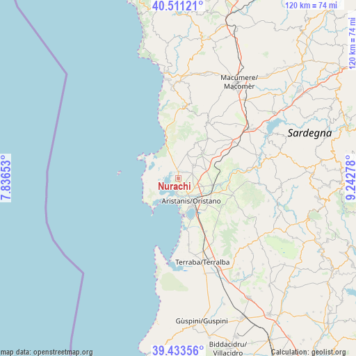
Nurachi GPS coordinates[2]
39° 58' 28.236" North, 8° 32' 22.74" East
| Map corner | latitude | longitude |
|---|---|---|
| Upper-left | 40.51121°, | 7.83653° |
| Center: | 39.97451°, | 8.53965° |
| Lower-right: | 39.43356°, | 9.24278° |
| Map W x H: | 119.8×119.8 km | = 74.4×74.4mi |
| max Lat: | 47.04031° ⇑88.1% North |
| Nurachi: | 39.97451° |
| min Lat: | ⇓11.9% South 35.50142° |
| min Long | Nurachi | max Long |
| 6.69888° | 8.53965° | 18.48682° |
| W 12.5%⇐ | ⇒87.5% E |
Elevation
Elevation of Nurachi is 6 m = 20 ft, and this is 300.7 m = 987 ft below average elevation for this country.
| Max E: |
2085 m = 6841 ft | 96.6% |
| Avg. | 306.7 m = 1006 ft | |
| Nurachi | 6 m = 20 ft | |
Min E: |
-4 m = -13 ft | 3.4% |
See also: Italy elevation on elevation.city.
Geographical zone
Nurachi is located in North temperate zone (between Tropic of Cancer and the Arctic Circle). Distance of this Northern Tropic circle is 1838.8 km =1142.6 mi to South.| Distance of | km | miles | from Nurachi |
|---|---|---|---|
| North Pole | 5562.3 | 3456.3 | to North |
| Arctic Circle | 2956.4 | 1837 | to North |
| Tropic Cancer | 1838.8 | 1142.6 | to South |
| Equator | 4444.7 | 2761.8 | to South |


Nearby cities:
15 places around Nurachi: (largest is in red/bold)
• Baratili San Pietro
2.4 km =1.5 mi,  35°
35°
• Cabras
5.1 km =3.2 mi,  186°
186°
• Donigala Fenugheddu
5.2 km =3.2 mi,  147°
147°
• Milis
11.8 km =7.3 mi, 44°
• Narbolia
8.7 km =5.4 mi,  20°
20°
• Nuraxinieddu
6.5 km =4 mi,  128°
128°
• Oristano
9.1 km =5.7 mi, 150°
• Riola Sardo
2.1 km =1.3 mi,  3°
3°
• San Vero Milis
6.6 km =4.1 mi,  48°
48°
• Siamaggiore
8.6 km =5.3 mi,  108°
108°
• Silì
9.4 km =5.8 mi, 131°
• Solanas
5.1 km =3.2 mi,  166°
166°
• Solarussa
11.6 km =7.2 mi,  100°
100°
• Tramatza
9.9 km =6.2 mi,  71°
71°
• Zeddiani
5 km =3.1 mi, 71°
Sources, notices
• [Note1] Compared only with cities in Italy existing in our database
• [Src1] Map data: © OpenStreetMap contributors (CC-BY-SA)
• [Src2] Other city data from geonames.org with taken over terms of usage.
• [Src3] Geographical zone / Annual Mean Temperature by Robert A. Rohde @ Wikipedia
