Zeddiani geodata
Zeddiani (Sardinia) is a seat of a third-order administrative division; located in Italy in Europe/Rome (GMT+2) time zone. With population of 1,035 people, there are 6527 cities with bigger population in this country. Compared to other cities in Italy, 88% of cities are located further ↑North; 86.7% of cities are located further →East and 92.1% of cities have higher elevation than Zeddiani. Note1


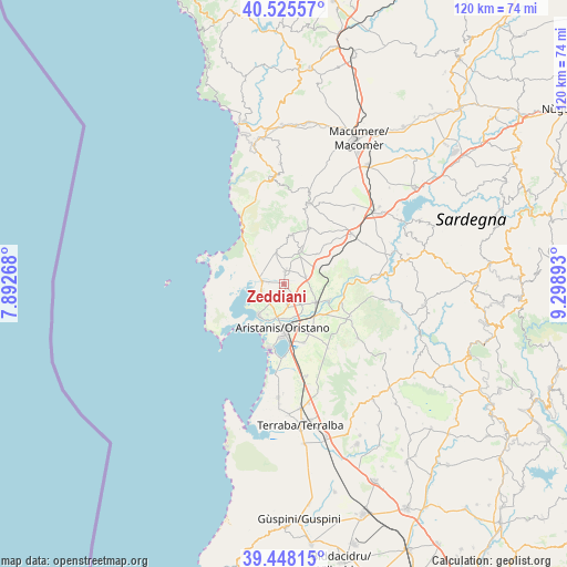
Zeddiani GPS coordinates[2]
39° 59' 20.328" North, 8° 35' 44.88" East
| Map corner | latitude | longitude |
|---|---|---|
| Upper-left | 40.52557°, | 7.89268° |
| Center: | 39.98898°, | 8.5958° |
| Lower-right: | 39.44815°, | 9.29893° |
| Map W x H: | 119.8×119.8 km | = 74.4×74.4mi |
| max Lat: | 47.04031° ⇑88% North |
| Zeddiani: | 39.98898° |
| min Lat: | ⇓12% South 35.50142° |
| min Long | Zeddiani | max Long |
| 6.69888° | 8.5958° | 18.48682° |
| W 13.3%⇐ | ⇒86.7% E |
Elevation
Elevation of Zeddiani is 14 m = 46 ft, and this is 292.7 m = 960 ft below average elevation for this country.
| Max E: |
2085 m = 6841 ft | 92.1% |
| Avg. | 306.7 m = 1006 ft | |
| Zeddiani | 14 m = 46 ft | |
Min E: |
-4 m = -13 ft | 7.9% |
See also: Italy elevation on elevation.city.
Geographical zone
Zeddiani is located in North temperate zone (between Tropic of Cancer and the Arctic Circle). Distance of this Northern Tropic circle is 1840.4 km =1143.6 mi to South.| Distance of | km | miles | from Zeddiani |
|---|---|---|---|
| North Pole | 5560.7 | 3455.3 | to North |
| Arctic Circle | 2954.8 | 1836 | to North |
| Tropic Cancer | 1840.4 | 1143.6 | to South |
| Equator | 4446.4 | 2762.9 | to South |


Nearby cities:
15 places around Zeddiani: (largest is in red/bold)
• Baratili San Pietro
3.4 km =2.1 mi,  276°
276°
• Bauladu
7.4 km =4.6 mi,  61°
61°
• Cabras
8.6 km =5.3 mi,  218°
218°
• Donigala Fenugheddu
6.3 km =3.9 mi,  197°
197°
• Milis
7.7 km =4.8 mi,  27°
27°
• Narbolia
6.8 km =4.2 mi,  345°
345°
• Nurachi
5 km =3.1 mi,  251°
251°
• Nuraxinieddu
5.6 km =3.5 mi,  177°
177°
• Riola Sardo
4.7 km =2.9 mi, 276°
• San Vero Milis
2.8 km =1.7 mi,  4°
4°
• Siamaggiore
5.5 km =3.4 mi,  142°
142°
• Silì
8.2 km =5.1 mi,  164°
164°
• Solanas
7.5 km =4.7 mi,  208°
208°
• Solarussa
7.7 km =4.8 mi,  119°
119°
• Tramatza
4.8 km =3 mi,  71°
71°
Sources, notices
• [Note1] Compared only with cities in Italy existing in our database
• [Src1] Map data: © OpenStreetMap contributors (CC-BY-SA)
• [Src2] Other city data from geonames.org with taken over terms of usage.
• [Src3] Geographical zone / Annual Mean Temperature by Robert A. Rohde @ Wikipedia
