Mascalucia geodata
Mascalucia (Sicily) is a seat of a third-order administrative division; located in Italy in Europe/Rome (GMT+2) time zone. With population of 29,910 people, there are 275 cities with bigger population in this country. Compared to other cities in Italy, 98.6% of cities are located further ↑North; 87.6% of cities are located further ←West and 73% of cities have lower elevation than Mascalucia. Note1


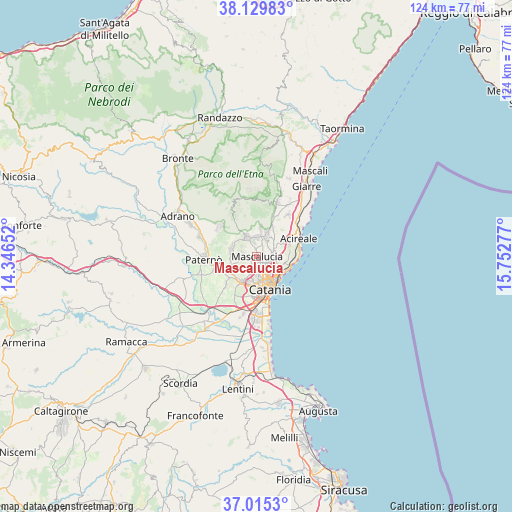
Mascalucia GPS coordinates[2]
37° 34' 28.74" North, 15° 2' 58.704" East
| Map corner | latitude | longitude |
|---|---|---|
| Upper-left | 38.12983°, | 14.34652° |
| Center: | 37.57465°, | 15.04964° |
| Lower-right: | 37.0153°, | 15.75277° |
| Map W x H: | 123.9×123.9 km | = 77×77mi |
| max Lat: | 47.04031° ⇑98.6% North |
| Mascalucia: | 37.57465° |
| min Lat: | ⇓1.4% South 35.50142° |
| min Long | Mascalucia | max Long |
| 6.69888° | 15.04964° | 18.48682° |
| W 87.6%⇐ | ⇒12.4% E |
Elevation
Elevation of Mascalucia is 425 m = 1394 ft, and this is 118.3 m = 388 ft above average elevation for this country.
| Max E: |
2085 m = 6841 ft | 27% |
| Mascalucia | 425 m 1394 ft | |
| Avg. | 306.7 m = 1006 ft | |
Min E: |
-4 m = -13 ft | 73% |
See also: Italy elevation on elevation.city.
Geographical zone
Mascalucia is located in North temperate zone (between Tropic of Cancer and the Arctic Circle). Distance of this Northern Tropic circle is 1572 km =976.8 mi to South.| Distance of | km | miles | from Mascalucia |
|---|---|---|---|
| North Pole | 5829.2 | 3622.1 | to North |
| Arctic Circle | 3223.3 | 2002.9 | to North |
| Tropic Cancer | 1572 | 976.8 | to South |
| Equator | 4177.9 | 2596 | to South |


Nearby cities:
15 places around Mascalucia: (largest is in red/bold)
• Aci Bonaccorsi
5.6 km =3.5 mi,  64°
64°
• Camporotondo Etneo
4.2 km =2.6 mi,  256°
256°
• Canalicchio
5.6 km =3.5 mi,  132°
132°
• Carrubazza-Motta
5.7 km =3.5 mi,  114°
114°
• Gravina di Catania
1.9 km =1.2 mi,  142°
142°
• Nicolosi
5.5 km =3.4 mi,  339°
339°
• Pedara
5.5 km =3.4 mi,  6°
6°
• San Giovanni la Punta
3.9 km =2.4 mi,  86°
86°
• San Gregorio di Catania
5.5 km =3.4 mi,  98°
98°
• San Pietro Clarenza
2.4 km =1.5 mi,  254°
254°
• Sant'Agata Li Battiati
3.3 km =2.1 mi, 125°
• Trecastagni
5.2 km =3.2 mi,  28°
28°
• Tremestieri Etneo
2.8 km =1.7 mi, 112°
• Viagrande
5.8 km =3.6 mi,  47°
47°
• Villaggio del Pino-Le Ginestre
4.1 km =2.5 mi,  282°
282°
Sources, notices
• [Note1] Compared only with cities in Italy existing in our database
• [Src1] Map data: © OpenStreetMap contributors (CC-BY-SA)
• [Src2] Other city data from geonames.org with taken over terms of usage.
• [Src3] Geographical zone / Annual Mean Temperature by Robert A. Rohde @ Wikipedia
