Viagrande geodata
Viagrande (Sicily) is a seat of a third-order administrative division; located in Italy in Europe/Rome (GMT+2) time zone. With population of 6,880 people, there are 1417 cities with bigger population in this country. Compared to other cities in Italy, 98.4% of cities are located further ↑North; 87.9% of cities are located further ←West and 70.5% of cities have lower elevation than Viagrande. Note1


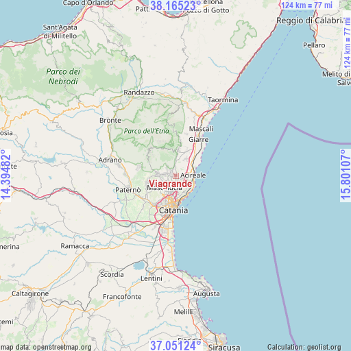
Viagrande GPS coordinates[2]
37° 36' 37.152" North, 15° 5' 52.584" East
| Map corner | latitude | longitude |
|---|---|---|
| Upper-left | 38.16523°, | 14.39482° |
| Center: | 37.61032°, | 15.09794° |
| Lower-right: | 37.05124°, | 15.80107° |
| Map W x H: | 123.9×123.9 km | = 77×77mi |
| max Lat: | 47.04031° ⇑98.4% North |
| Viagrande: | 37.61032° |
| min Lat: | ⇓1.6% South 35.50142° |
| min Long | Viagrande | max Long |
| 6.69888° | 15.09794° | 18.48682° |
| W 87.9%⇐ | ⇒12.1% E |
Elevation
Elevation of Viagrande is 399 m = 1309 ft, and this is 92.3 m = 303 ft above average elevation for this country.
| Max E: |
2085 m = 6841 ft | 29.5% |
| Viagrande | 399 m 1309 ft | |
| Avg. | 306.7 m = 1006 ft | |
Min E: |
-4 m = -13 ft | 70.5% |
See also: Italy elevation on elevation.city.
Geographical zone
Viagrande is located in North temperate zone (between Tropic of Cancer and the Arctic Circle). Distance of this Northern Tropic circle is 1576 km =979.3 mi to South.| Distance of | km | miles | from Viagrande |
|---|---|---|---|
| North Pole | 5825.2 | 3619.6 | to North |
| Arctic Circle | 3219.3 | 2000.4 | to North |
| Tropic Cancer | 1576 | 979.3 | to South |
| Equator | 4181.9 | 2598.5 | to South |


Nearby cities:
15 places around Viagrande: (largest is in red/bold)
• Aci Bonaccorsi
1.8 km =1.1 mi,  152°
152°
• Aci Catena
3.9 km =2.4 mi,  96°
96°
• Aci Sant'Antonio
2.3 km =1.4 mi,  105°
105°
• Lavinaio-Monterosso
3.5 km =2.2 mi,  9°
9°
• Mascalucia
5.8 km =3.6 mi,  227°
227°
• Maugeri
3.2 km =2 mi, 146°
• Monterosso
3.7 km =2.3 mi,  350°
350°
• Pedara
3.9 km =2.4 mi,  292°
292°
• Pennisi
4.9 km =3 mi,  27°
27°
• San Giovanni la Punta
3.7 km =2.3 mi,  185°
185°
• San Gregorio di Catania
4.9 km =3 mi,  166°
166°
• Santa Maria la Stella
2.5 km =1.6 mi,  53°
53°
• Trecastagni
1.8 km =1.1 mi, 287°
• Tremestieri Etneo
5.3 km =3.3 mi,  198°
198°
• Valverde
4.4 km =2.7 mi, 148°
Sources, notices
• [Note1] Compared only with cities in Italy existing in our database
• [Src1] Map data: © OpenStreetMap contributors (CC-BY-SA)
• [Src2] Other city data from geonames.org with taken over terms of usage.
• [Src3] Geographical zone / Annual Mean Temperature by Robert A. Rohde @ Wikipedia
