Trecastagni geodata
Trecastagni (Sicily) is a seat of a third-order administrative division; located in Italy in Europe/Rome (GMT+2) time zone. With population of 10,135 people, there are 937 cities with bigger population in this country. Compared to other cities in Italy, 98.4% of cities are located further ↑North; 87.8% of cities are located further ←West and 83.1% of cities have lower elevation than Trecastagni. Note1


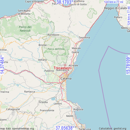
Trecastagni GPS coordinates[2]
37° 36' 55.548" North, 15° 4' 40.656" East
| Map corner | latitude | longitude |
|---|---|---|
| Upper-left | 38.1703°, | 14.37484° |
| Center: | 37.61543°, | 15.07796° |
| Lower-right: | 37.05638°, | 15.78109° |
| Map W x H: | 123.9×123.9 km | = 77×77mi |
| max Lat: | 47.04031° ⇑98.4% North |
| Trecastagni: | 37.61543° |
| min Lat: | ⇓1.6% South 35.50142° |
| min Long | Trecastagni | max Long |
| 6.69888° | 15.07796° | 18.48682° |
| W 87.8%⇐ | ⇒12.2% E |
Elevation
Elevation of Trecastagni is 574 m = 1883 ft, and this is 267.3 m = 877 ft above average elevation for this country.
| Max E: |
2085 m = 6841 ft | 16.9% |
| Trecastagni | 574 m 1883 ft | |
| Avg. | 306.7 m = 1006 ft | |
Min E: |
-4 m = -13 ft | 83.1% |
See also: Italy elevation on elevation.city.
Geographical zone
Trecastagni is located in North temperate zone (between Tropic of Cancer and the Arctic Circle). Distance of this Northern Tropic circle is 1576.5 km =979.6 mi to South.| Distance of | km | miles | from Trecastagni |
|---|---|---|---|
| North Pole | 5824.6 | 3619.2 | to North |
| Arctic Circle | 3218.7 | 2000 | to North |
| Tropic Cancer | 1576.5 | 979.6 | to South |
| Equator | 4182.4 | 2598.8 | to South |


Nearby cities:
15 places around Trecastagni: (largest is in red/bold)
• Aci Bonaccorsi
3.3 km =2.1 mi,  129°
129°
• Aci Catena
5.7 km =3.5 mi,  100°
100°
• Aci Sant'Antonio
4.1 km =2.5 mi,  106°
106°
• Lavinaio-Monterosso
3.7 km =2.3 mi,  39°
39°
• Mascalucia
5.2 km =3.2 mi,  208°
208°
• Maugeri
4.8 km =3 mi, 132°
• Monterosso
3.3 km =2.1 mi,  21°
21°
• Nicolosi
4.5 km =2.8 mi,  278°
278°
• Pedara
2.1 km =1.3 mi,  296°
296°
• Pennisi
5.5 km =3.4 mi,  46°
46°
• San Giovanni la Punta
4.5 km =2.8 mi,  162°
162°
• Santa Maria la Stella
3.9 km =2.4 mi,  76°
76°
• Tremestieri Etneo
5.6 km =3.5 mi,  179°
179°
• Valverde
5.9 km =3.7 mi,  136°
136°
• Viagrande
1.8 km =1.1 mi, 107°
Sources, notices
• [Note1] Compared only with cities in Italy existing in our database
• [Src1] Map data: © OpenStreetMap contributors (CC-BY-SA)
• [Src2] Other city data from geonames.org with taken over terms of usage.
• [Src3] Geographical zone / Annual Mean Temperature by Robert A. Rohde @ Wikipedia
